IMAGES TAKEN NEAR TO
High Dyke, GRANTHAM, NG33 5BE
Introduction
This page details the photographs taken nearby to High Dyke, NG33 5BE by members of the Geograph project.
The Geograph project started in 2005 with the aim of publishing, organising and preserving representative images for every square kilometre of Great Britain, Ireland and the Isle of Man.

There are currently over 7.5m images from over14,400 individuals and you can help contribute to the project by visiting https://www.geograph.org.uk
Image Map
Images are licensed for reuse under creativecommons.org/licenses/by-sa/2.0
Notes
- Clicking on the map will re-center to the selected point.
- The higher the marker number, the further away the image location is from the centre of the postcode.
Image Listing (13 Images Found)
Images are licensed for reuse under creativecommons.org/licenses/by-sa/2.0
Image
Details
Distance
1
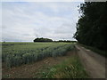
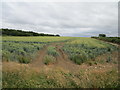
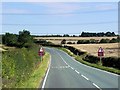
Wheat field and road to High Dyke Farm
Image: © Jonathan Thacker
Taken: 4 Jul 2020
0.06 miles
2
Above Stoke tunnel
The planned walk to stand atop Stoke Tunnel was abandoned due to torrential rain. Stoke Summit marked the beginning of the stretch of railway line to Peterborough where A4 Pacific locomotive Mallard reached 126mph in 1938.
Image: © Andrew Tatlow
Taken: 19 Apr 2006
0.10 miles
3
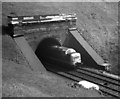
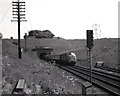
Stoke Tunnel - North end
As Class 55 "Deltic" emerges from Stoke Tunnel with a Kings Cross - Edinburgh service.
Image: © Peter Kazmierczak
Taken: Unknown
0.14 miles
4
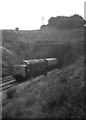
Deepest Lincolnshire
A Class 55 "Deltic" loco leaves Stoke Tunnel with a London to West Riding of Yorkshire train.
Image: © Peter Kazmierczak
Taken: Unknown
0.15 miles
5
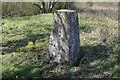
Triangulation Pillar TP6204 above Stoke tunnel
Flush Bracket S2105
Image: © J.Hannan-Briggs
Taken: 1 Apr 2012
0.15 miles
6
On top of Stoke Tunnel sits a Triangulation Pillar whilst trains speed by below in excess of 100 mph
Looking eastward.
Image: © Peter Wood
Taken: 4 Mar 2014
0.16 miles
7
Approaching High Dyke
A Kings Cross - Leeds train leaves Stoke Tunnel and approaches High Dyke in the summer of 1969.
Image: © Peter Kazmierczak
Taken: Unknown
0.17 miles
8
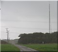
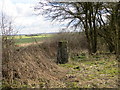
Wheat field near High Dyke
The trees on the left mark the line of the former railway which linked ironstone quarries in nearby parts of Lincolnshire and Leicestershire with the East Coast Main Line.
Image: © Jonathan Thacker
Taken: 4 Jul 2020
0.20 miles
10
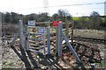
Network Rail access gate at Stoke Tunnel
This gate gives access to the high speed Edinburgh to London railway line. For use by authorised persons only!
Image: © Kate Jewell
Taken: 16 Mar 2007
0.21 miles