IMAGES TAKEN NEAR TO
Castle Bytham, GRANTHAM, NG33 4SW
Introduction
This page details the photographs taken nearby to NG33 4SW by members of the Geograph project.
The Geograph project started in 2005 with the aim of publishing, organising and preserving representative images for every square kilometre of Great Britain, Ireland and the Isle of Man.

There are currently over 7.5m images from over14,400 individuals and you can help contribute to the project by visiting https://www.geograph.org.uk
Image Map
Images are licensed for reuse under creativecommons.org/licenses/by-sa/2.0
Notes
- Clicking on the map will re-center to the selected point.
- The higher the marker number, the further away the image location is from the centre of the postcode.
Image Listing (10 Images Found)
Images are licensed for reuse under creativecommons.org/licenses/by-sa/2.0
Image
Details
Distance
1
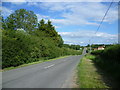
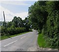
Down the dip on Morkery Lane
This is by the entrance to Angel Wells Farm, looking in the direction of Castle Bytham.
Image: © Marathon
Taken: 27 Jun 2015
0.05 miles
2
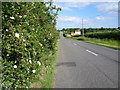
Roses in the hedgerow alongside Morkery Lane
This is by the entrance to Angel Wells Farm, looking in the direction of Castle Bytham.
Image: © Marathon
Taken: 27 Jun 2015
0.05 miles

5

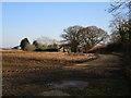
Morkery Lane eastwards
A pipeline passes below. See
Image: © Andrew Tatlow
Taken: 21 Jun 2009
0.08 miles
6

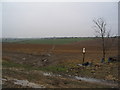
Pipeline signs
Evidence of the TOTAL Finaline multi-product pipeline passing below.The pipeline starts at the Lindsey Oil Refinery and finishes at the Buncefield Terminal in Hertfordshire; it also connects to a joint venture pipeline leading into London Heathrow airport.
The Total Pipelines website http://www.totalpipelines.co.uk/ says "Finaline is 10 inches in diameter and operates at a pressure of 110bar, having the capacity of 6million litres per day.".
It makes one think!
Image: © Andrew Tatlow
Taken: 21 Jun 2009
0.11 miles
7

Morkery Lane and dismantled railway NW of Castle Bytham: aerial 2020
Image: © Chris
Taken: 4 Jan 2020
0.12 miles
10

Poultry sheds off Lobthorpe to Castle Bytham footpath
Image: © Tim Heaton
Taken: 12 Feb 2006
0.22 miles