IMAGES TAKEN NEAR TO
Little Bytham, GRANTHAM, NG33 4RD
Introduction
This page details the photographs taken nearby to NG33 4RD by members of the Geograph project.
The Geograph project started in 2005 with the aim of publishing, organising and preserving representative images for every square kilometre of Great Britain, Ireland and the Isle of Man.

There are currently over 7.5m images from over14,400 individuals and you can help contribute to the project by visiting https://www.geograph.org.uk
Image Map
Images are licensed for reuse under creativecommons.org/licenses/by-sa/2.0
Notes
- Clicking on the map will re-center to the selected point.
- The higher the marker number, the further away the image location is from the centre of the postcode.
Image Listing (5 Images Found)
Images are licensed for reuse under creativecommons.org/licenses/by-sa/2.0
Image
Details
Distance
1
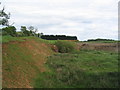
Old sand pits behind Warren Cottage
Just off (and invisible from) the road from Little Bytham to Witham on the Hill
Image: © Tim Heaton
Taken: 28 May 2006
0.14 miles
2
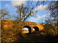
Bridge over the route of the former Edenham and Little Bytham Railway
The Edenham and Little Bytham Railway was a short lived line primarily intended to serve the Grimsthorpe Estate https://en.wikipedia.org/wiki/Edenham_and_Little_Bytham_Railway
Image: © Jonathan Thacker
Taken: 10 Jan 2020
0.19 miles
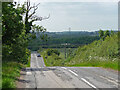
3

Road to Little Bytham
This Unnamed road from Witham On The Hill joins the B1176 after 1Km or so.
Image: © J.Hannan-Briggs
Taken: 30 Dec 2012
0.19 miles
5
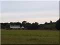
Warren Cottage
The land on the south of the road from Little Bytham to South Witham is part of the Ancaster estate, and is very sandy. Before it was commercially extracted it was used as a warren, and this is Warren Cottage.
Image: © Bob Harvey
Taken: 12 Oct 2014
0.25 miles