IMAGES TAKEN NEAR TO
Creeton, GRANTHAM, NG33 4QB
Introduction
This page details the photographs taken nearby to NG33 4QB by members of the Geograph project.
The Geograph project started in 2005 with the aim of publishing, organising and preserving representative images for every square kilometre of Great Britain, Ireland and the Isle of Man.

There are currently over 7.5m images from over14,400 individuals and you can help contribute to the project by visiting https://www.geograph.org.uk
Image Map
Images are licensed for reuse under creativecommons.org/licenses/by-sa/2.0
Notes
- Clicking on the map will re-center to the selected point.
- The higher the marker number, the further away the image location is from the centre of the postcode.
Image Listing (115 Images Found)
Images are licensed for reuse under creativecommons.org/licenses/by-sa/2.0
Image
Details
Distance
1
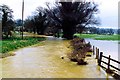
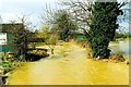
Flooding at Creeton, near Bourne, Lincolnshire
Heavy rain brought flooding to many areas during the late winter of 1999, particularly here at Creeton lying in the valley of the West Glen River which burst its banks and thousands of gallons of water rushed into the road and surrounding meadows, turning the countryside into muddy lakes and cutting off houses on either side of the B1176 at the very foot of the hillside. See also Image
Image: © Rex Needle
Taken: 21 Mar 1999
0.01 miles
3
Flooding at Creeton, near Bourne, Lincolnshire
The West Glen River burst its banks in March 1999 after a period of heavy rain which brought flooding to many areas, particularly here at the village of Creeton where water flowed into the road and surrounding meadows, turning the countryside into muddy lakes and cutting off houses on either side of the approach road. See also Image
Image: © Rex Needle
Taken: 21 Mar 1999
0.02 miles
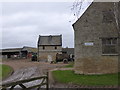
4
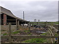
Pigeoncote at Brownlow Farm, Creeton
Seventeenth century pigeoncote https://historicengland.org.uk/listing/the-list/list-entry/1166147 The barn on the right is also listed https://historicengland.org.uk/listing/the-list/list-entry/1062820
Image: © Jonathan Thacker
Taken: 30 Oct 2019
0.02 miles
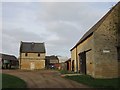
5
Brownlow Farm
Traditional mixed arable/dairy farming in Creeton.
The Barn is a grade II listed building.
Image: © Bob Harvey
Taken: 2 Mar 2014
0.02 miles
6
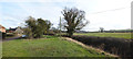
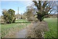
Creeton village
The bank of the River Glen
This is a composite of 10 images, stitched with Microsoft ICE, which yielded an image 15563x10352 pixels, which is available on demand. It was scaled down to fit Geograph
Image: © Bob Harvey
Taken: 18 Feb 2018
0.02 miles
7

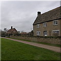
Brownlow Farm nameboard
Sign at the entrance of Image]
Image: © Bob Harvey
Taken: 2 Mar 2014
0.02 miles
8
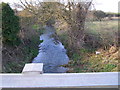
West Glen River
This was taken from the B1176 roadbridge which spans the West Glen River in Creeton.
Image: © Brian Green
Taken: 6 Jan 2008
0.03 miles