IMAGES TAKEN NEAR TO
Hanby, GRANTHAM, NG33 4HH
Introduction
This page details the photographs taken nearby to NG33 4HH by members of the Geograph project.
The Geograph project started in 2005 with the aim of publishing, organising and preserving representative images for every square kilometre of Great Britain, Ireland and the Isle of Man.

There are currently over 7.5m images from over14,400 individuals and you can help contribute to the project by visiting https://www.geograph.org.uk
Image Map
Images are licensed for reuse under creativecommons.org/licenses/by-sa/2.0
Notes
- Clicking on the map will re-center to the selected point.
- The higher the marker number, the further away the image location is from the centre of the postcode.
Image Listing (7 Images Found)
Images are licensed for reuse under creativecommons.org/licenses/by-sa/2.0
Image
Details
Distance
5
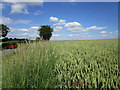
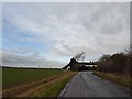
Wheat field near Lenton
The Roman King Street crosses the road from Lenton to Folkingham about where the car stands on the left of the picture.
Image: © Jonathan Thacker
Taken: 5 Jul 2019
0.17 miles
6
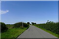
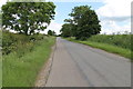
Footpath to Lenton
The Roman road, King Street, is believed to have run across here (see OS map), but there is no visible sign of it in the neighbouring fields.
Image: © Tim Heaton
Taken: 12 Aug 2021
0.20 miles
7
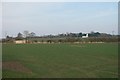
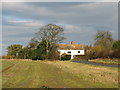
Across the fields
The hedge at the other side of this field marks the line of the former Roman Road of King Street. The white building is the farm known as The Grange
Image: © Bob Harvey
Taken: 13 Mar 2016
0.21 miles