IMAGES TAKEN NEAR TO
East End, GRANTHAM, NG33 4EH
Introduction
This page details the photographs taken nearby to East End, NG33 4EH by members of the Geograph project.
The Geograph project started in 2005 with the aim of publishing, organising and preserving representative images for every square kilometre of Great Britain, Ireland and the Isle of Man.

There are currently over 7.5m images from over14,400 individuals and you can help contribute to the project by visiting https://www.geograph.org.uk
Image Map
Images are licensed for reuse under creativecommons.org/licenses/by-sa/2.0
Notes
- Clicking on the map will re-center to the selected point.
- The higher the marker number, the further away the image location is from the centre of the postcode.
Image Listing (79 Images Found)
Images are licensed for reuse under creativecommons.org/licenses/by-sa/2.0
Image
Details
Distance
1
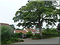
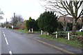
Picturesque Ingoldsby
Some fine old buildings and a magnificent tree.
The white cottage is an 18th century vernacular building which was thatched at one point. Below the dormers a 20th century extension to ghre ground floor has brought the frontage forward.
beyond that is a late georgean former shop, with typical shop double frontage.
Image: © Bob Harvey
Taken: 4 Aug 2013
0.03 miles
2
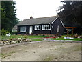
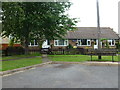
Wooden bungalow
An unusual and well-maintained building.
Image: © Bob Harvey
Taken: 4 Aug 2013
0.04 miles
3
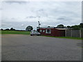
Social club and playing field
Ingoldsby has no pub, but does have a social club associated with the playing fields.
The description from the BBC Domesday project is as true today as it was then: http://www.bbc.co.uk/history/domesday/dblock/GB-500000-330000/page/8
Image: © Bob Harvey
Taken: 4 Aug 2013
0.05 miles
5
Put out more flags
This bungalow gateway was bedecked with flags at the time the UK left the EU
Image: © Bob Harvey
Taken: 1 Feb 2020
0.09 miles
6
Bungalows
A pretty little crescent of small 1960s bungalows in Rosemary Rise
Image: © Bob Harvey
Taken: 4 Aug 2013
0.10 miles
7
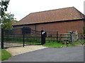
Athelstan Hall Gates
These magnificent gates guard the drive to a modern house built behind Church Farm, one of whose barns is in the background of the picture. The modern Athelstan Hall is not visible from the road, although one of its gables is in this photograph, and from that it appears to be 21st century in design.
Image: © Bob Harvey
Taken: 4 Aug 2013
0.12 miles
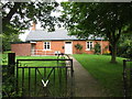
8
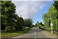
Entering Ingoldsby on Main Street
Ingoldsby = ‘Farmstead or village of a man called Ingjaldr’ https://www.oxfordreference.com/view/10.1093/acref/9780199609086.001.0001/acref-9780199609086
Image: © Tim Heaton
Taken: 16 Sep 2021
0.13 miles
9
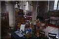
The Church of St Bartholomew: The view from the door
There are two steps down from the main door to the interior, and this view is from inside the doorway, looking diagonally toward the pulpit and chancel arch
Image: © Bob Harvey
Taken: 20 Oct 2018
0.15 miles
10
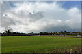
Fields behind the houses
Ingoldsby is more-or less a Ribbon development along this road from the church towards Lenton. These fields are to the south of the village.
Image: © Bob Harvey
Taken: 3 Nov 2013
0.15 miles