IMAGES TAKEN NEAR TO
Lower Bassingthorpe, GRANTHAM, NG33 4ED
Introduction
This page details the photographs taken nearby to NG33 4ED by members of the Geograph project.
The Geograph project started in 2005 with the aim of publishing, organising and preserving representative images for every square kilometre of Great Britain, Ireland and the Isle of Man.

There are currently over 7.5m images from over14,400 individuals and you can help contribute to the project by visiting https://www.geograph.org.uk
Image Map
Images are licensed for reuse under creativecommons.org/licenses/by-sa/2.0
Notes
- Clicking on the map will re-center to the selected point.
- The higher the marker number, the further away the image location is from the centre of the postcode.
Image Listing (8 Images Found)
Images are licensed for reuse under creativecommons.org/licenses/by-sa/2.0
Image
Details
Distance
3
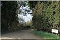
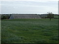
Entrance to Sycamore Farm, Lower Bassingthorpe
Through a gap in the evergreen trees.
Image: © J.Hannan-Briggs
Taken: 25 Mar 2012
0.03 miles
5
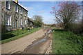
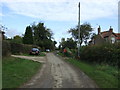
Sycamore Farm, Lower Bassingthorpe
A limestone farmhouse with ashlar cut window surrounds. The muddy track leads to the farm in Image
Image: © Kate Jewell
Taken: 16 Mar 2007
0.13 miles
7
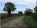
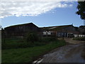
Lane towards Lower Bassingthorpe
Heading east.
Image: © JThomas
Taken: 12 Oct 2012
0.18 miles
8
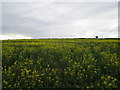
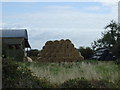
Oilseed rape near Lower Bassingthorpe
Must be a late planting to be flowering at this time.
Image: © Jonathan Thacker
Taken: 20 Jun 2020
0.21 miles