IMAGES TAKEN NEAR TO
Bitchfield, GRANTHAM, NG33 4DR
Introduction
This page details the photographs taken nearby to NG33 4DR by members of the Geograph project.
The Geograph project started in 2005 with the aim of publishing, organising and preserving representative images for every square kilometre of Great Britain, Ireland and the Isle of Man.

There are currently over 7.5m images from over14,400 individuals and you can help contribute to the project by visiting https://www.geograph.org.uk
Image Map
Images are licensed for reuse under creativecommons.org/licenses/by-sa/2.0
Notes
- Clicking on the map will re-center to the selected point.
- The higher the marker number, the further away the image location is from the centre of the postcode.
Image Listing (7 Images Found)
Images are licensed for reuse under creativecommons.org/licenses/by-sa/2.0
Image
Details
Distance
1
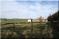
The Old School near Bitchfield
A public footpath runs up to the house and on towards Boothby Pagnell following the West Glen River.
Image: © Kate Jewell
Taken: 16 Mar 2007
0.03 miles
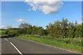
2
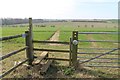
Stile and Footpath Entrance off the B1176 at Bitchfield
Image: © J.Hannan-Briggs
Taken: 25 Mar 2012
0.06 miles
3
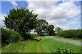
Overgrown footpath
A useful footpath from Bitchfield alongside the busy B1176; becoming overgrown at this point.
Image: © Tim Heaton
Taken: 29 Jul 2021
0.08 miles
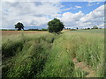
4
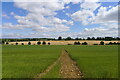
Footpath crossing fields of flax and barley
The upper reach of the West Glen River runs along the line of trees between the fields
Image: © Tim Heaton
Taken: 29 Jul 2021
0.10 miles
5
West Glen River
A rather grand name for a very modest stream.
Image: © Jonathan Thacker
Taken: 20 Jun 2020
0.14 miles
7
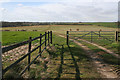
Bridleway near Bitchfield
This bridleway leads from the B1176 to Boothby Pagnell along this serviceable farm track. The West Glen River runs in the dip across the centre of the photograph.
Image: © Kate Jewell
Taken: 16 Mar 2007
0.23 miles