IMAGES TAKEN NEAR TO
Grantham Road, GRANTHAM, NG33 4DE
Introduction
This page details the photographs taken nearby to Grantham Road, NG33 4DE by members of the Geograph project.
The Geograph project started in 2005 with the aim of publishing, organising and preserving representative images for every square kilometre of Great Britain, Ireland and the Isle of Man.

There are currently over 7.5m images from over14,400 individuals and you can help contribute to the project by visiting https://www.geograph.org.uk
Image Map
Images are licensed for reuse under creativecommons.org/licenses/by-sa/2.0
Notes
- Clicking on the map will re-center to the selected point.
- The higher the marker number, the further away the image location is from the centre of the postcode.
Image Listing (5 Images Found)
Images are licensed for reuse under creativecommons.org/licenses/by-sa/2.0
Image
Details
Distance
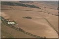
1
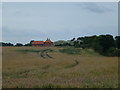
Boothby Lodge
View of the farmhouse over the fields
Image: © Bob Harvey
Taken: 4 Aug 2013
0.02 miles
3
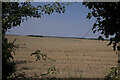
After the harvest
Fields with the wheat all cut
Image: © Bob Harvey
Taken: 5 Sep 2021
0.15 miles
4
Unnamed circular stand of trees southeast of Boothby Pagnell: aerial 2020 (1)
Image: © Chris
Taken: 22 Mar 2020
0.16 miles