IMAGES TAKEN NEAR TO
School Lane, GRANTHAM, NG33 4BT
Introduction
This page details the photographs taken nearby to School Lane, NG33 4BT by members of the Geograph project.
The Geograph project started in 2005 with the aim of publishing, organising and preserving representative images for every square kilometre of Great Britain, Ireland and the Isle of Man.

There are currently over 7.5m images from over14,400 individuals and you can help contribute to the project by visiting https://www.geograph.org.uk
Image Map
Images are licensed for reuse under creativecommons.org/licenses/by-sa/2.0
Notes
- Clicking on the map will re-center to the selected point.
- The higher the marker number, the further away the image location is from the centre of the postcode.
Image Listing (141 Images Found)
Images are licensed for reuse under creativecommons.org/licenses/by-sa/2.0
Image
Details
Distance
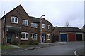
1
The end of the close
Infill housing, dated to the Blair years by having detached garages, a planning quirk of the times
Image: © Bob Harvey
Taken: 23 Oct 2020
0.04 miles
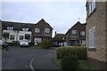
2
Hall Court
A small infill housing estate from the very early years of the 21st century - the detached garages are a give-away, dating this to the period of the Blair/prescott government and their strange planning laws.
Image: © Bob Harvey
Taken: 23 Oct 2020
0.05 miles
3
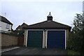
Double detached garage
I am assuming that the two homes associated with this block have two colours of front door.
Detached garage blocks were a characteristic of the years at the start of the 21st century, when John Prescott was the minister in charge of many things, including housing. It was a requirement that houses be built without provision for motor cars (an attempt to encourage the use of public transport). This may have made sense to the metropolitan mind, but in rural Lincolnshire was wholly ridiculous. Thus, housebuilders took to building separate garages, on separate plots, and selling them "separately" to the houses.
Image: © Bob Harvey
Taken: 23 Oct 2020
0.05 miles
4
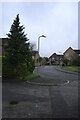
Along the cul-de-sac
Post-millennial housing in Hall Close.
Image: © Bob Harvey
Taken: 23 Oct 2020
0.06 miles
5
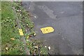
Hydrant and marked kerb
Freshly painted, these are the companions to Image
Image: © Bob Harvey
Taken: 23 Oct 2020
0.08 miles
6
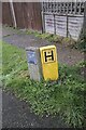
Hydrant marker and pipe routing
Pair of marker posts for the water system. See nearby Image
Image: © Bob Harvey
Taken: 23 Oct 2020
0.09 miles
8
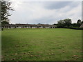
Village Green and bungalows, Ropsley
Image: © Jonathan Thacker
Taken: 16 Jul 2019
0.09 miles
9
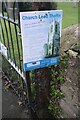
St Peter's Church: notice at the gate
There have been many lead thefts in recent years. This notice urges the public to be vigilant.
Image: © Bob Harvey
Taken: 23 Oct 2020
0.09 miles
10
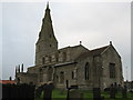
Saint Peter's Church, Ropsley.
The Anglican parish church is dedicated to Saint Peter and appears to date from Norman times. Some parts of the church appear also to be of Saxon origin. The building dates back to at least 1380.
Image: © Bob Danylec
Taken: 4 Dec 2005
0.09 miles