IMAGES TAKEN NEAR TO
Wray Close, NOTTINGHAM, NG3 2FS
Introduction
This page details the photographs taken nearby to Wray Close, NG3 2FS by members of the Geograph project.
The Geograph project started in 2005 with the aim of publishing, organising and preserving representative images for every square kilometre of Great Britain, Ireland and the Isle of Man.

There are currently over 7.5m images from over14,400 individuals and you can help contribute to the project by visiting https://www.geograph.org.uk
Image Map
Images are licensed for reuse under creativecommons.org/licenses/by-sa/2.0
Notes
- Clicking on the map will re-center to the selected point.
- The higher the marker number, the further away the image location is from the centre of the postcode.
Image Listing (41 Images Found)
Images are licensed for reuse under creativecommons.org/licenses/by-sa/2.0
Image
Details
Distance
1
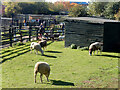
Stonebridge City Farm
Stonebridge City Farm in the St Ann's area of Nottingham is located on a small site that was originally intended for a school. It opened in 1980 and now has a collection of farm animals including these sheep. It operates as a charity, staffed by volunteers, and gives an opportunity for inner city children to become familiar with animals that they might otherwise never encounter.
Image: © Stephen McKay
Taken: 16 Oct 2022
0.05 miles
2
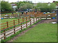
Nottingham - NG3 (St Ann's)
Stonebridge City Farm as seen from a public footpath connecting Stonebridge Road with Ferrers Walk (an internal Estate path).
Image: © David Hallam-Jones
Taken: 12 May 2012
0.06 miles
3
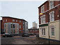
Nottingham, NG3 - St Ann's Area
A view from the Jersey Gardens side of the former Lord Alcester pub towards the summit of St Mathias' Road with Woodhouse Street opposite. The pub was built in the 1950s but following its closure due to the economic collapse of its business it was converted into nine self-contained flats in 2012. The pub took its name from Admiral Frederick Beauchamp Paget Seymour, the 1st Lord Alcester (1821-95), the British naval Commander-in-Chief of the Channel Fleet between 1874-77 and of the Mediterranean Fleet between 1880-83.
Image: © David Hallam-Jones
Taken: 24 Jan 2013
0.06 miles
4
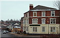
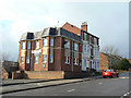
Nottingham, NG3 - St Ann's Area.
The former Lord Alcester pub, near the summit of St Mathias' Road, that was built in the 1950s and that has been converted into nine self-contained flats (2012). The premises, that are still called by their original name, have been extended on their Carlton Road side. The pub took its name from Admiral Frederick Beauchamp Paget Seymour, the 1st Lord Alcester (1821-95), the British naval Commander-in-Chief of the Channel Fleet between 1874-77 and of the Mediterranean Fleet between 1880-83.
Image: © David Hallam-Jones
Taken: 24 Jan 2013
0.06 miles
5
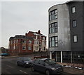
The Lord Alcester
Victorian pub on St Mathias Road, with modern extension.
Image: © Alan Murray-Rust
Taken: 8 Mar 2009
0.06 miles
6
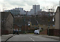
Jersey Gardens
Part of the St Anns redevelopment of the early 1970s, with the Victoria Centre flats on the skyline.
Image: © Alan Murray-Rust
Taken: 8 Mar 2009
0.07 miles
7
Nottingham, NG3 - St Ann's
A view of the former Lord Alcester pub near the top of St Mathias' Road as seen from Woodhouse Street. The metallic bow-edged building is part of an apartment complex called Albany House, that hosts a community cafe. The pub was built in the 1950s but was extended and converted into nine self-contained flats in 2012.
Image: © David Hallam-Jones
Taken: 24 Jan 2013
0.08 miles
8
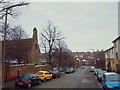
Nottingham NG3 Carlton Rd (Lower End)
The lower part of St Mathias’ Road (once known as Element Hill), with Carlton Road (the B686 road) in the distance. The former St Mathias' Anglican Church was closed in 2003 and the building eventually became the home of the Coptic Orthodox Church of St Mary & St George in March 2009. St. Matthias' Anglican Church was originally consecrated in 1867.
Image: © David Hallam-Jones
Taken: 24 Jan 2013
0.08 miles
9
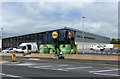
Lidl supermarket, Carlton Road
Due to open 2 days after this picture was taken. It is on the site of the former Wright and Dobson dye works, which was demolished in 2002.
Image: © Alan Murray-Rust
Taken: 23 May 2017
0.10 miles
10
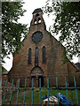
St. Matthias' Church, Sneinton
Just after closure.
Image: © Andrew Abbott
Taken: 6 Sep 2008
0.10 miles