IMAGES TAKEN NEAR TO
Anstey Rise, NOTTINGHAM, NG3 2BY
Introduction
This page details the photographs taken nearby to Anstey Rise, NG3 2BY by members of the Geograph project.
The Geograph project started in 2005 with the aim of publishing, organising and preserving representative images for every square kilometre of Great Britain, Ireland and the Isle of Man.

There are currently over 7.5m images from over14,400 individuals and you can help contribute to the project by visiting https://www.geograph.org.uk
Image Map
Images are licensed for reuse under creativecommons.org/licenses/by-sa/2.0
Notes
- Clicking on the map will re-center to the selected point.
- The higher the marker number, the further away the image location is from the centre of the postcode.
Image Listing (54 Images Found)
Images are licensed for reuse under creativecommons.org/licenses/by-sa/2.0
Image
Details
Distance
1
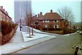
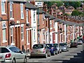
Nottingham in the 1980s - Corner of Elford Rise and Anstey Rise, Sneinton
Apart from more cars, the scene here is very similar in 2020. The three young trees in the foreground did not survive.
Image: © Nigel Thompson
Taken: 2 Feb 1982
0.04 miles
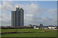
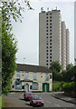
2
Burrows Court tower block stands sentinel
Built 1967, refurbished 1994, empty since 2004, and still derelict in 2016 despite a national shortage of housing.
Image: © Chris Morgan
Taken: 19 Jul 2016
0.05 miles
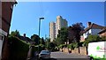
3
Windmill Lane Flats
A solitary tower block built on a hill.
Image: © Alan Murray-Rust
Taken: 21 Jan 2007
0.06 miles
4
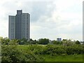
Windmill Lane Flats
Recreating this 'First' for the square https://www.geograph.org.uk/photo/318402 . There has been considerable increase in the vegetation in the intervening period.
Image: © Alan Murray-Rust
Taken: 27 May 2021
0.08 miles
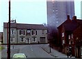
6
The Red Cow
Both pub and high rise block are unoccupied
Image: © Alan Murray-Rust
Taken: 29 May 2008
0.10 miles
7
Nottingham in the 1980s - The Red Cow Pub, Windmill Lane
40 years later, the houses on the right and Windmill Lane flats still survive, but the public house has been demolished.
Image: © Nigel Thompson
Taken: 2 Feb 1982
0.12 miles
8
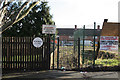
Windmill Close, Sneinton
The circular cast-iron street name was the standard Nottingham design for tween-wars housing estates. The prohibition of cycling is currently superfluous.
Image: © Alan Murray-Rust
Taken: 11 Feb 2007
0.12 miles
9
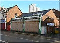
Former Co-op
Roundels on the white panels of the pillars have the monogram NCS, but even without them this frontage has all the hallmarks of having been a Co-op store. It ceased to be one when the superstore Image on the opposite side of the road was opened, and has since had a variety of occupants, that last one being a charity. It has been unoccupied for some months now and I feel it unlikely that either it or its successor will find new occupants.
Image: © Alan Murray-Rust
Taken: 8 Mar 2009
0.14 miles
10
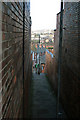
Stairway from Windmill Lane to Spalding Street, Sneinton
Image: © Alan Murray-Rust
Taken: 11 Feb 2007
0.14 miles