IMAGES TAKEN NEAR TO
St. Chads Road, NOTTINGHAM, NG3 2AU
Introduction
This page details the photographs taken nearby to St. Chads Road, NG3 2AU by members of the Geograph project.
The Geograph project started in 2005 with the aim of publishing, organising and preserving representative images for every square kilometre of Great Britain, Ireland and the Isle of Man.

There are currently over 7.5m images from over14,400 individuals and you can help contribute to the project by visiting https://www.geograph.org.uk
Image Map
Images are licensed for reuse under creativecommons.org/licenses/by-sa/2.0
Notes
- Clicking on the map will re-center to the selected point.
- The higher the marker number, the further away the image location is from the centre of the postcode.
Image Listing (116 Images Found)
Images are licensed for reuse under creativecommons.org/licenses/by-sa/2.0
Image
Details
Distance
1
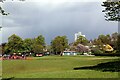
A view across King Edward Park
Sun in the foreground but wintry showers around.
Image: © Alan Murray-Rust
Taken: 6 May 2021
0.05 miles
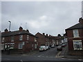
3
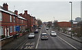
Nottingham, NG3 - Carlton Road
The edge of the city centre is seen in the distance in this view of Carlton Road (the B686). The pillar box on the left is situated at the junction of Denstone Road.
Image: © David Hallam-Jones
Taken: 24 Jan 2013
0.07 miles
4
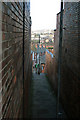
Stairway from Windmill Lane to Spalding Street, Sneinton
Image: © Alan Murray-Rust
Taken: 11 Feb 2007
0.07 miles
5
St. Cuthbert's Road
A short street linking Carlton Road with Spalding Road.
Image: © Jonathan Thacker
Taken: 9 Jul 2018
0.07 miles
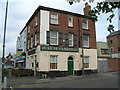
6
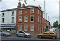
The former Duke of Cambridge public house
This closed around 2013 and was converted quite quickly into student flats. There's nothing now that really indicates its original use. The building dates from 1878.
Image: © Alan Murray-Rust
Taken: 23 May 2017
0.08 miles
7
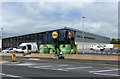
Lidl supermarket, Carlton Road
Due to open 2 days after this picture was taken. It is on the site of the former Wright and Dobson dye works, which was demolished in 2002.
Image: © Alan Murray-Rust
Taken: 23 May 2017
0.09 miles
8
Nottingham - NG3 (Sneinton)
This gate post at the edge of King Edward Park off Dakeyne Street is all that remains of The General Lunatic Asylum for the Town & County of Nottingham. In 1873, once all its private patients had been transferred to The Coppice Hospital, Mapperley it became known as The County Lunatic Asylum. This was in turn replaced by Saxondale Hospital that served residents of Notts from 1902-88. During the late 50s and the 60s at least part of the Sneinton buildings were used by the Dakeyn Street Lads' Club (later to become The Oliver Hind Boys Brigade).
Image: © David Hallam-Jones
Taken: 5 May 2012
0.09 miles
9
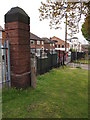
Nottingham - NG3 (Sneinton)
This gate post at the edge of King Edward Park, off Dakeyne Street, is all that remains of The General Lunatic Asylum for the Town & County of Nottingham. In 1873, once all its private patients had been transferred to The Coppice Hospital, Mapperley it became known as The County Lunatic Asylum. This was in turn replaced by Saxondale Hospital that served residents of Notts from 1902-88. During the late 50s and the 60s at least part of the Sneinton buildings were used by the Dakeyn Street Lads' Club (later to become The Oliver Hind Boys Brigade).
Image: © David Hallam-Jones
Taken: 5 May 2012
0.10 miles
10
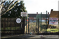
Windmill Close, Sneinton
The circular cast-iron street name was the standard Nottingham design for tween-wars housing estates. The prohibition of cycling is currently superfluous.
Image: © Alan Murray-Rust
Taken: 11 Feb 2007
0.10 miles