IMAGES TAKEN NEAR TO
The Hollow, GRANTHAM, NG32 3RQ
Introduction
This page details the photographs taken nearby to The Hollow, NG32 3RQ by members of the Geograph project.
The Geograph project started in 2005 with the aim of publishing, organising and preserving representative images for every square kilometre of Great Britain, Ireland and the Isle of Man.

There are currently over 7.5m images from over14,400 individuals and you can help contribute to the project by visiting https://www.geograph.org.uk
Image Map
Images are licensed for reuse under creativecommons.org/licenses/by-sa/2.0
Notes
- Clicking on the map will re-center to the selected point.
- The higher the marker number, the further away the image location is from the centre of the postcode.
Image Listing (14 Images Found)
Images are licensed for reuse under creativecommons.org/licenses/by-sa/2.0
Image
Details
Distance
1
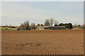
Crowland Farm
View from Waterwell Lane to Crowland Farm
Image: © Richard Croft
Taken: 2 Apr 2015
0.12 miles
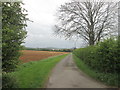
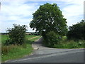
2
Road to Crowland Farm
This is just north of Ancaster showing the road to Crowland Farm; Ermine Street is just behind where I am standing.
Image: © Marathon
Taken: 12 Aug 2017
0.14 miles
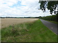
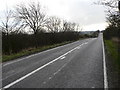
4
Ermine Street (aka High Dike) north of Ancaster
The start of a remarkably straight 11 miles of road and green lane to the outskirts of Lincoln
Image: © Tim Heaton
Taken: 4 Sep 2023
0.16 miles
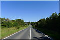
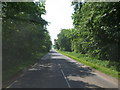
5

The Hollow
Ermine Street north of Ancaster
Image: © Richard Croft
Taken: 19 Jul 2010
0.17 miles
9
Ermine Street Roman Road
Looking S near the entrance to Crowland Farm
Image: © Ian Carrington
Taken: 26 Dec 2005
0.19 miles
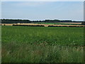
10
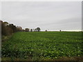
Field of sugar beet neat Crowland Farm
Image: © Jonathan Thacker
Taken: 6 Nov 2019
0.20 miles