IMAGES TAKEN NEAR TO
Pottergate Road, GRANTHAM, NG32 3QZ
Introduction
This page details the photographs taken nearby to Pottergate Road, NG32 3QZ by members of the Geograph project.
The Geograph project started in 2005 with the aim of publishing, organising and preserving representative images for every square kilometre of Great Britain, Ireland and the Isle of Man.

There are currently over 7.5m images from over14,400 individuals and you can help contribute to the project by visiting https://www.geograph.org.uk
Image Map
Images are licensed for reuse under creativecommons.org/licenses/by-sa/2.0
Notes
- Clicking on the map will re-center to the selected point.
- The higher the marker number, the further away the image location is from the centre of the postcode.
Image Listing (36 Images Found)
Images are licensed for reuse under creativecommons.org/licenses/by-sa/2.0
Image
Details
Distance
1
Ancaster Goods Shed
The old railway goods shed is now a small industrial unit. See Image]
Taken from the train.
Image: © Ashley Dace
Taken: 28 May 2011
0.03 miles
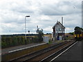
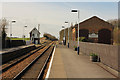
2
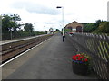
Ancaster station
Ancaster station was opened on 16th June 1857 by the Boston, Sleaford & Midland Counties Railway. Trains now run to Nottingham in one direction and Skegness in the other. The signal box is still operational.
Image: © Marathon
Taken: 12 Aug 2017
0.05 miles
3
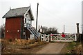
Level crossing and signal box, Ancaster
The level crossing is where Pottergate Lane crosses the railway just west of Ancaster station.
Image: © Simon Mortimer
Taken: 1 Jan 2009
0.05 miles
4
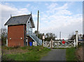
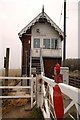
Ancaster signal box and Pottergate Road level crossing
Pottergate Road is a restricted byway, so the gates probably see very little use. There is one traditional wooden gate and one modern steel gate. The signal box is a typical Great Northern Railway small brick box.
Image: © Alan Murray-Rust
Taken: 19 Nov 2014
0.05 miles
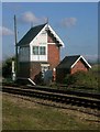
5
Ancaster signal box
Built in 1873 on the Grantham to Sleaford section of the Great Northern Railway. The signal box controlled the station and sidings of the small goods yard at Ancaster.
Image: © Simon Mortimer
Taken: 1 Jan 2009
0.06 miles
6

Approaching Pottergate Road crossing
This part of Pottergate Road is a restricted byway.
Image: © Jonathan Thacker
Taken: 27 Jul 2019
0.06 miles
7
The signal box at Ancaster station
Ancaster station was opened on 16th June 1857 by the Boston, Sleaford & Midland Counties Railway. Trains now run to Nottingham in one direction and Skegness in the other. In this photograph a Skegness bound train is approaching the platform but will not stop. The signal box is still operational.
Image: © Marathon
Taken: 12 Aug 2017
0.07 miles
8
Ancaster signalbox from the north-west
The signalbox stands just west of Ancaster station, which (in turn) lies to the west of High Dike (Ermine Street). The line is the old Great Northern's line from Grantham to Sleaford (and beyond), and the little signalbox still carries under its eaves the fancy barge-boards that were characteristic of GNR boxes. Alan Murray-Rust's contribution shows the box from the south http://www.geograph.org.uk/photo/4253520 while Richard Croft's shows the view from the station: http://www.geograph.org.uk/photo/4412344
Image: © Stefan Czapski
Taken: 31 Mar 2008
0.07 miles
9
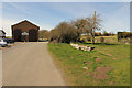
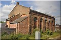
Station Yard
Former engine shed and remnants of a goods platform at Ancaster Station
Image: © Richard Croft
Taken: 2 Apr 2015
0.07 miles
10
Ancaster Station
Platforms, former engine shed and Pottergate Road signal box at Ancaster Station
Image: © Richard Croft
Taken: 2 Apr 2015
0.08 miles