IMAGES TAKEN NEAR TO
Ancaster, GRANTHAM, NG32 3PZ
Introduction
This page details the photographs taken nearby to NG32 3PZ by members of the Geograph project.
The Geograph project started in 2005 with the aim of publishing, organising and preserving representative images for every square kilometre of Great Britain, Ireland and the Isle of Man.

There are currently over 7.5m images from over14,400 individuals and you can help contribute to the project by visiting https://www.geograph.org.uk
Image Map
Images are licensed for reuse under creativecommons.org/licenses/by-sa/2.0
Notes
- Clicking on the map will re-center to the selected point.
- The higher the marker number, the further away the image location is from the centre of the postcode.
Image Listing (4 Images Found)
Images are licensed for reuse under creativecommons.org/licenses/by-sa/2.0
Image
Details
Distance
1
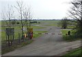
RAF Barkston Heath Crash Gate (Number 3)
This is one of seven crash gates situated around the airfield. These gates are used by the MOD Fire Service, mainly to exit the airfield in the event of a plane crash taking place off the main site.
Image: © Billy-Death
Taken: 10 Apr 2010
0.09 miles
2
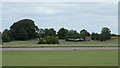
Fire practice aircraft, RAF Barkston Heath
I think this is the remains of a Canberra.
The flat fields that made this an ideal site for an airfield are evident.
Image: © John Goldsmith
Taken: 30 Aug 2009
0.13 miles
3
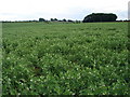
Looking towards Willoughby Heath Farm
Across the field of peas.
Image: © Ian Paterson
Taken: 15 Jun 2007
0.21 miles
4
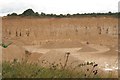
Limestone quarry, Ancaster 2020 (1)
One of many limestone quarries near Ancaster.
The area has been quarried for thousands of years and yields an oolitic limestone varying in colour from white/beige to grey. For further details see https://goldholme.com/our-lincolnshire-limestone/
Aerial shot: Image
Image: © Chris
Taken: 23 Aug 2020
0.25 miles