IMAGES TAKEN NEAR TO
Ermine Street, GRANTHAM, NG32 3PW
Introduction
This page details the photographs taken nearby to Ermine Street, NG32 3PW by members of the Geograph project.
The Geograph project started in 2005 with the aim of publishing, organising and preserving representative images for every square kilometre of Great Britain, Ireland and the Isle of Man.

There are currently over 7.5m images from over14,400 individuals and you can help contribute to the project by visiting https://www.geograph.org.uk
Image Map
Images are licensed for reuse under creativecommons.org/licenses/by-sa/2.0
Notes
- Clicking on the map will re-center to the selected point.
- The higher the marker number, the further away the image location is from the centre of the postcode.
Image Listing (93 Images Found)
Images are licensed for reuse under creativecommons.org/licenses/by-sa/2.0
Image
Details
Distance
1
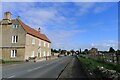
Ermine Street running through Ancaster
Ancaster Hall, on the left, is a Listed Grade II 17th-19th house (now flats) https://historicengland.org.uk/listing/the-list/list-entry/1062421?section=official-list-entry
Image: © Tim Heaton
Taken: 28 Sep 2022
0.02 miles
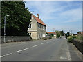
2
Ancaster Hall, the old kitchen
This separate building to the Hall was originally the kitchen. 17th century in origin, Listed Grade II for group value.
Image: © Alan Murray-Rust
Taken: 19 Nov 2014
0.05 miles
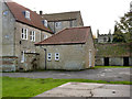
4
Ancaster Hall
17th century house, later extended and altered, although these two fronts date from the original build date. Listed Grade II*. The wall in front of the house is 18th century, and the English Heritage listing describes it as 'evidently intended to lend dignity to the facade.'
Image: © Alan Murray-Rust
Taken: 19 Nov 2014
0.06 miles
5

Defibrillator at the Village Hall
Tucked away between the porch and the utility block is this Defibrillator, but no-one would know. The normal sign does not appear anywhwere on the property.
For context, see Image
Image: © Bob Harvey
Taken: 23 Feb 2019
0.06 miles
6
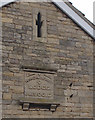
Datestone
The datestone on the gable end of Image
It reads "Heart & Hand Lodge A.1900.D"
Image: © Bob Harvey
Taken: 23 Feb 2019
0.06 miles

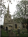
8
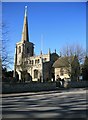
Ancaster Church
As seen from the road alongside the church.
Image: © roger geach
Taken: 7 Mar 2010
0.06 miles
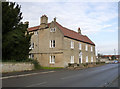
10

Ancaster Village Hall
Built in 1900 as a Masonic lodge, this is now the village hall.
See Image for the datestone above the porch
Image: © Bob Harvey
Taken: 23 Feb 2019
0.07 miles