IMAGES TAKEN NEAR TO
Sudbrook Road, GRANTHAM, NG32 3AW
Introduction
This page details the photographs taken nearby to Sudbrook Road, NG32 3AW by members of the Geograph project.
The Geograph project started in 2005 with the aim of publishing, organising and preserving representative images for every square kilometre of Great Britain, Ireland and the Isle of Man.

There are currently over 7.5m images from over14,400 individuals and you can help contribute to the project by visiting https://www.geograph.org.uk
Image Map
Images are licensed for reuse under creativecommons.org/licenses/by-sa/2.0
Notes
- Clicking on the map will re-center to the selected point.
- The higher the marker number, the further away the image location is from the centre of the postcode.
Image Listing (23 Images Found)
Images are licensed for reuse under creativecommons.org/licenses/by-sa/2.0
Image
Details
Distance
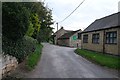
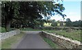
1
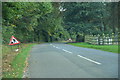
Sudbrook Road, Carlton Scroop
Approaching some roadworks, towards Sudbrook.
Image: © J.Hannan-Briggs
Taken: 9 Oct 2016
0.05 miles
2
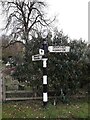
Direction Sign ? Signpost in Carlton Scroop
Located on the south side of the junction of the A607 Main Street and Sudbrook Road in Carlton Scroop parish. 3 arms and annulus finial.
Milestone Society National ID: LI_SK9545
Image: © G Munday
Taken: 18 Nov 2020
0.09 miles
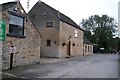
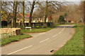
4
Sudbrook Road junction, Carlton Scroop
Image: © Steve Fareham
Taken: 11 Sep 2012
0.10 miles
7
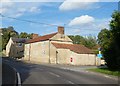
Junction of A607 with Charity Street, Carlton Scroop
Image: © David Smith
Taken: 18 Sep 2018
0.11 miles
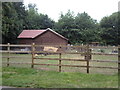
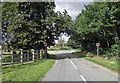
10
Sudbrook Road
Entering Carlton Scroop on Sudbrook Road
Image: © Richard Croft
Taken: 9 Apr 2015
0.12 miles