IMAGES TAKEN NEAR TO
The Close, GRANTHAM, NG32 2NP
Introduction
This page details the photographs taken nearby to The Close, NG32 2NP by members of the Geograph project.
The Geograph project started in 2005 with the aim of publishing, organising and preserving representative images for every square kilometre of Great Britain, Ireland and the Isle of Man.

There are currently over 7.5m images from over14,400 individuals and you can help contribute to the project by visiting https://www.geograph.org.uk
Image Map
Images are licensed for reuse under creativecommons.org/licenses/by-sa/2.0
Notes
- Clicking on the map will re-center to the selected point.
- The higher the marker number, the further away the image location is from the centre of the postcode.
Image Listing (37 Images Found)
Images are licensed for reuse under creativecommons.org/licenses/by-sa/2.0
Image
Details
Distance
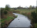
1
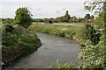
The river Witham looking north
As seen off the road bridge looking North.
Image: © roger geach
Taken: 5 May 2009
0.13 miles
2
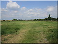
Grass field by the River Witham at Barkston
Image: © Jonathan Thacker
Taken: 16 Jul 2019
0.14 miles
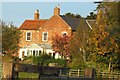
4
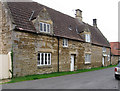
Barkston - house on south side of West Street
Image: © Dave Bevis
Taken: 26 Jul 2012
0.14 miles
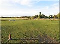
8
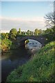
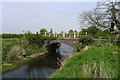
The Bridge at Barkston
The picture was taken looking upstream from the Council picnic area beside the River Witham.
Image: © Glyn Baker
Taken: 13 May 2012
0.18 miles
9
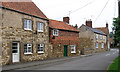
Barkston - houses at east end of West Street
Image: © Dave Bevis
Taken: 26 Jul 2012
0.18 miles
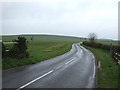
10
Station Road crossing the River Witham at Barkston
Image: © Tim Heaton
Taken: 21 Apr 2014
0.18 miles