IMAGES TAKEN NEAR TO
Main Street, GRANTHAM, NG32 1SF
Introduction
This page details the photographs taken nearby to Main Street, NG32 1SF by members of the Geograph project.
The Geograph project started in 2005 with the aim of publishing, organising and preserving representative images for every square kilometre of Great Britain, Ireland and the Isle of Man.

There are currently over 7.5m images from over14,400 individuals and you can help contribute to the project by visiting https://www.geograph.org.uk
Image Map
Images are licensed for reuse under creativecommons.org/licenses/by-sa/2.0
Notes
- Clicking on the map will re-center to the selected point.
- The higher the marker number, the further away the image location is from the centre of the postcode.
Image Listing (199 Images Found)
Images are licensed for reuse under creativecommons.org/licenses/by-sa/2.0
Image
Details
Distance
1
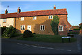
Carrier's Cottage, Eaton
On the corner of Vicarage Lane.
Image: © Kate Jewell
Taken: 21 Oct 2007
0.01 miles
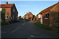
2
Eaton, Leicestershire
First cottages on Main Street.
Image: © Kate Jewell
Taken: 21 Oct 2007
0.02 miles
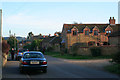
3
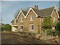
Former estate cottages, Eaton
There is a bench mark http://www.geograph.org.uk/photo/5180169 on the far corner of the projecting gables.
Image: © Alan Murray-Rust
Taken: 31 Oct 2016
0.02 miles
4
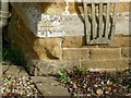
Bench mark, 1 Main Street, Eaton
See http://www.geograph.org.uk/photo/5180165 for location.
Image: © Alan Murray-Rust
Taken: 31 Oct 2016
0.02 miles
5
Main Street, Eaton
The houses to the right are the converted barns of Ivy Stud Farm, see Image
Image: © Kate Jewell
Taken: 21 Oct 2007
0.03 miles
6
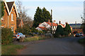
Vicarage Lane, Eaton
Allotments to the right. Look at the map to see how Vicarage Lane curves round the north of the village from Main Street in the west to rejoin Main Street in the east.
Image: © Kate Jewell
Taken: 5 Jan 2010
0.03 miles
7
Vicarage Lane, Eaton
Vicarage Lane runs right round the north side of Eaton and rejoins Main Street below the church. The stable on the right belongs to the cottage on the left.
Image: © Kate Jewell
Taken: 21 Oct 2007
0.04 miles
8
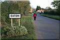
Coming into Eaton
Eaton is a small village in the north east of Leicestershire. It is on the Jurassic outcrop that runs from just south of Middlesbrough down the East coast, through the Midlands and on to the south coast at Weymouth. Most of the older and some of the most recent houses in the village are built of the local ironstone associated with this geology. See http://www.nvr.org.uk/istg/iqem01l.gif
Image: © Kate Jewell
Taken: 21 Oct 2007
0.04 miles
9
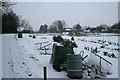
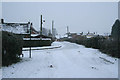
No gardening today!
Eaton Vicarage Lane allotments under a covering of snow.
Image: © Kate Jewell
Taken: 5 Jan 2010
0.05 miles
10
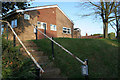
Eaton Village Hall
Built in the second half of the 20th Century this village hall is in a totally unsympathetic style to the rest of the village. It is in a prominent position above Main Street as well.
Image: © Kate Jewell
Taken: 21 Oct 2007
0.05 miles