IMAGES TAKEN NEAR TO
The Rock, GRANTHAM, NG32 1RX
Introduction
This page details the photographs taken nearby to The Rock, NG32 1RX by members of the Geograph project.
The Geograph project started in 2005 with the aim of publishing, organising and preserving representative images for every square kilometre of Great Britain, Ireland and the Isle of Man.

There are currently over 7.5m images from over14,400 individuals and you can help contribute to the project by visiting https://www.geograph.org.uk
Image Map
Images are licensed for reuse under creativecommons.org/licenses/by-sa/2.0
Notes
- Clicking on the map will re-center to the selected point.
- The higher the marker number, the further away the image location is from the centre of the postcode.
Image Listing (81 Images Found)
Images are licensed for reuse under creativecommons.org/licenses/by-sa/2.0
Image
Details
Distance
1
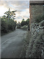
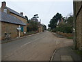
The Rock, Branston
Looking north towards Main Street
Image: © Kate Jewell
Taken: 2 Aug 2005
0.02 miles
2
Branston, Leicestershire
Looking down Main Street. The building on the right is the Wheel Inn, good for food!
Image: © Kate Jewell
Taken: 2 Aug 2005
0.02 miles
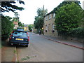
3
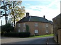
Main Street, Branston
Large house on the junction with The Rock.
Image: © Kate Jewell
Taken: 21 Oct 2007
0.03 miles
4
The Village Pump, Branston
The pump in Branston is on the footpath at the end of The Rock. The letters halfway down are D of R: for the Duke of Rutland. Branston was one of the Belvoir Estate villages.
Image: © Kate Jewell
Taken: 2 Aug 2005
0.04 miles
5
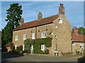
Lings Farmhouse, Branston
Dating from around 1800. Ironstone with brick dressings and black pantile roof. Listed Grade II.
Image: © Alan Murray-Rust
Taken: 31 Oct 2016
0.04 miles
6
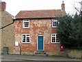
Old post office at Branston
This cottage was once the post office for this attractive village. The collection box is still in use.
Image: © Richard Green
Taken: 12 Nov 2010
0.05 miles
7
Wilds Farmhouse, Branston
Mid 18th century farmhouse, 4 bays, 2 storeys with attic. Ironstone with red pantile roof, Listed Grade II.
Image: © Alan Murray-Rust
Taken: 31 Oct 2016
0.06 miles
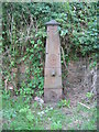
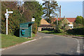
8
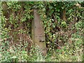
Disused pump at Branston
This pump is by the footpath continuation of the lane called The Rock. Mains water only came to this village in 1958.
Image: © Richard Green
Taken: 11 Aug 2010
0.06 miles
9
Branston
Cycle Route 64 turns right to Knipton
Image: © Tim Heaton
Taken: 4 Mar 2011
0.07 miles
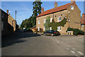
10
Main Street, Branston
The junction is with Waltham Road.
Image: © Kate Jewell
Taken: 21 Oct 2007
0.07 miles