IMAGES TAKEN NEAR TO
Knipton Road, GRANTHAM, NG32 1RT
Introduction
This page details the photographs taken nearby to Knipton Road, NG32 1RT by members of the Geograph project.
The Geograph project started in 2005 with the aim of publishing, organising and preserving representative images for every square kilometre of Great Britain, Ireland and the Isle of Man.

There are currently over 7.5m images from over14,400 individuals and you can help contribute to the project by visiting https://www.geograph.org.uk
Image Map
Images are licensed for reuse under creativecommons.org/licenses/by-sa/2.0
Notes
- Clicking on the map will re-center to the selected point.
- The higher the marker number, the further away the image location is from the centre of the postcode.
Image Listing (13 Images Found)
Images are licensed for reuse under creativecommons.org/licenses/by-sa/2.0
Image
Details
Distance
1
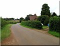
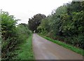
Knipton Road passes Croxton Lodge Cottages
Image: © Andrew Tatlow
Taken: 23 Aug 2012
0.02 miles
2
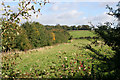
Fields above Knipton Reservoir
The woodland to the left borders the reservoir, an elusive body of water owned and managed by the Belvoir Castle Estate which has no public access.
Image: © Kate Jewell
Taken: 8 Oct 2008
0.13 miles
4

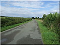
Farmland and woodland
Near Knipton Reservoir.
Image: © JThomas
Taken: 17 Aug 2013
0.15 miles
5
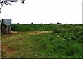
Farmland above Knipton Reservoir
At the top of the hill above the reservoir the farmland flattens out into a large plateau. This field has been lying fallow this year. Knipton Reservoir, seen in the distance, is managed by the Belvoir Castle Estate and lies in Image It is not accessible to the public.
Image: © Kate Jewell
Taken: 8 Oct 2008
0.17 miles
6
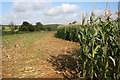
Maize crop near Branston
This is a view of the higher part of the field in Image The edge of the fallow area can just be made out at the far centre point. Knipton Reservoir is between this high ground and Reservoir Wood in the distance, both in Image
Image: © Kate Jewell
Taken: 8 Oct 2008
0.19 miles
9
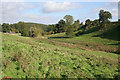
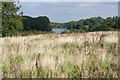
Pasture near Branston
This pasture to the east of Branston dips down sharply to the marshy course of a fast flowing stream before rising steeply on the other side. According to the map the bridleway climbs up at an almost impossible angle on its way to the top.
Image: © Kate Jewell
Taken: 8 Oct 2008
0.23 miles
10
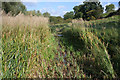
Livestock path
The reed bed has been mown to allow livestock easy access to water from the stream and, one assumes, Knipton Reservoir which is just beyond the trees in the distance.
Image: © Kate Jewell
Taken: 8 Oct 2008
0.25 miles