IMAGES TAKEN NEAR TO
Croxton Kerrial, GRANTHAM, NG32 1QY
Introduction
This page details the photographs taken nearby to NG32 1QY by members of the Geograph project.
The Geograph project started in 2005 with the aim of publishing, organising and preserving representative images for every square kilometre of Great Britain, Ireland and the Isle of Man.

There are currently over 7.5m images from over14,400 individuals and you can help contribute to the project by visiting https://www.geograph.org.uk
Image Map
Images are licensed for reuse under creativecommons.org/licenses/by-sa/2.0
Notes
- Clicking on the map will re-center to the selected point.
- The higher the marker number, the further away the image location is from the centre of the postcode.
Image Listing (12 Images Found)
Images are licensed for reuse under creativecommons.org/licenses/by-sa/2.0
Image
Details
Distance
1
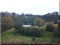
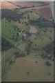
Fish-ponds of the former Croxton Abbey
Seen from the lower slopes of Windmill Hill. Other than the fish-ponds there's not much in this grid-square to show that there was once an abbey here. At least, that's what Pevsner says ('The Buildings of England: Leicestershire and Rutland', 1960). As there's no routine public access, we'd better take his word for it.
By the way, the local pronunciation of Croxton is 'Crowson'.
Image: © Stefan Czapski
Taken: 11 Mar 2009
0.07 miles
2
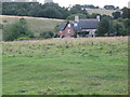
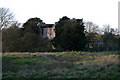
Croxton Park House
Grade II Listed stone house originating from the 16th century using materials from the Priory in the Park. A rather grand holiday let owned by the Belvoir Castle Estate. http://www.belvoircastle.com
Image: © Kate Jewell
Taken: 3 Aug 2005
0.07 miles
3
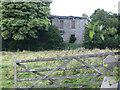
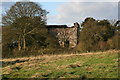
Old Croxton Park House
Formerly a hunting seat of the Duke of Rutland built by John, the third Duke of Rutland about 1730, using materials from the 12th century Premonstratensian Priory in the Park. Now a ruin.
Image: © Kate Jewell
Taken: 3 Aug 2005
0.11 miles
4
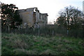
Old Croxton Park House
This shows the once grand north front of the 18th Century hunting lodge built by the third Duke of Rutland using materials from the 12th century Premonstratensian Priory. Note the remains of the curved colonnade which must have been a very grand feature.
Image: © Kate Jewell
Taken: 9 Nov 2007
0.11 miles
5
Two years on
Old Croxton Park House ruin two years after this: http://www.geograph.org.uk/photo/33194
Image: © Kate Jewell
Taken: 9 Nov 2007
0.12 miles
6
Old Croxton Park House
See Image for information. This shows the extent of the colonnade on the north front. Look at Google Earth to get a bird's eye view.
Image: © Kate Jewell
Taken: 9 Nov 2007
0.13 miles
7
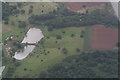
Croxton Park: aerial 2020 (2)
See https://historicengland.org.uk/listing/the-list/list-entry/1011244
Image: © Chris
Taken: 30 Aug 2020
0.14 miles
8
Croxton Park: aerial 2020 (1)
Site of Premonstratensian Abbey - see https://historicengland.org.uk/listing/the-list/list-entry/1011244
Image: © Chris
Taken: 30 Aug 2020
0.14 miles
9
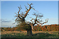
Stag-headed oak, Croxton Park
This is a common sight in ancient oak woodland. As they get older oaks tend to die back and loose branches. They are still an important habitat for a wide variety of insects and small animals and birds. Here this ancient tree is isolated in the field that holds the remnants of the old Premonstratensian Priory.
Compare with Image
Image: © Kate Jewell
Taken: 9 Nov 2007
0.14 miles
10
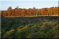
Field and woodland at Croxton Park
This field must have been the site of the 12th Century Premonstratensian Priory, of which nothing remains except a few earth mounds and ridges in the biologically important parkland and the stone building materials that were used for the hunting lodge, Image, and the houses on the site. See Image for more information about this SSSI.
Image: © Kate Jewell
Taken: 9 Nov 2007
0.16 miles