IMAGES TAKEN NEAR TO
Highfield Crescent, GRANTHAM, NG32 1QU
Introduction
This page details the photographs taken nearby to Highfield Crescent, NG32 1QU by members of the Geograph project.
The Geograph project started in 2005 with the aim of publishing, organising and preserving representative images for every square kilometre of Great Britain, Ireland and the Isle of Man.

There are currently over 7.5m images from over14,400 individuals and you can help contribute to the project by visiting https://www.geograph.org.uk
Image Map
Images are licensed for reuse under creativecommons.org/licenses/by-sa/2.0
Notes
- Clicking on the map will re-center to the selected point.
- The higher the marker number, the further away the image location is from the centre of the postcode.
Image Listing (91 Images Found)
Images are licensed for reuse under creativecommons.org/licenses/by-sa/2.0
Image
Details
Distance
1
Village post office and stores, Croxton Kerrial
This village is lucky, it still has its shop.
View from the junction of Middle Road with Main Street: the main A607 Melton Mowbray to Grantham road.
Image: © Kate Jewell
Taken: 30 Jan 2010
0.01 miles
2
Main Street in Croxton Kerrial, Leicestershire
Image: © Mat Fascione
Taken: 10 May 2008
0.03 miles
3
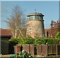
Lookout tower, Croxton Kerrial
The former windmill has been converted into a private house with its fine viewing room in place of the cap. When listed in 1990, the interior was largely stripped and the mill derelict. It is the only known example of a smock-mill tower in the county. Listed Grade II.
Image: © Alan Murray-Rust
Taken: 7 Nov 2016
0.05 miles
4
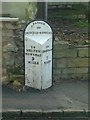
Milepost, Croxton Kerrial
Early to mid 19th century cast iron post, Listed Grade II. See http://www.geograph.org.uk/photo/5186966
Image: © Alan Murray-Rust
Taken: 7 Nov 2016
0.07 miles
5
Hillside Farmhouse, Croxton Kerrial
Late 18th century farmhouse with later alterations, ironstone and limestone with pantiled roof, Listed Grade II.
Image: © Alan Murray-Rust
Taken: 7 Nov 2016
0.07 miles
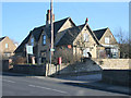
6
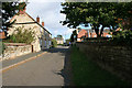
School Lane, Croxton Kerrial
The school in question is the building on the right. This photograph was taken from the same place as Image but looking in the other direction.
Image: © Kate Jewell
Taken: 8 Oct 2008
0.07 miles
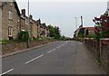
7
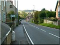
Main Street, Croxton Kerrial
Otherwise the A607 trunk road.
The presence of the milepost indicates that this was a turnpike road, in this instance linking Grantham and Melton Mowbray. The milepost is Listed Grade II and can be seen close up here http://www.geograph.org.uk/photo/5186968 .
Image: © Alan Murray-Rust
Taken: 7 Nov 2016
0.08 miles

9
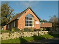
Croxton Kerrial Village Hall
On Main Street, below Middle Street.
Image: © Alan Murray-Rust
Taken: 7 Nov 2016
0.08 miles
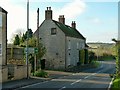
10
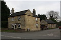
'The Old Forge' at the junction of the A607 and Saltby Road
There is an OS benchmark Image on the front of the house at its left hand corner
Image: © phil Richards
Taken: 7 May 2019
0.10 miles