IMAGES TAKEN NEAR TO
School Lane, GRANTHAM, NG32 1QR
Introduction
This page details the photographs taken nearby to School Lane, NG32 1QR by members of the Geograph project.
The Geograph project started in 2005 with the aim of publishing, organising and preserving representative images for every square kilometre of Great Britain, Ireland and the Isle of Man.

There are currently over 7.5m images from over14,400 individuals and you can help contribute to the project by visiting https://www.geograph.org.uk
Image Map
Images are licensed for reuse under creativecommons.org/licenses/by-sa/2.0
Notes
- Clicking on the map will re-center to the selected point.
- The higher the marker number, the further away the image location is from the centre of the postcode.
Image Listing (109 Images Found)
Images are licensed for reuse under creativecommons.org/licenses/by-sa/2.0
Image
Details
Distance
1
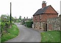
School Lane in Croxton Kerrial, Leicestershire
At the bottom of the lane on the corner of the A607 Main Street is The Peacock pub.
Image: © Mat Fascione
Taken: 10 May 2008
0.02 miles
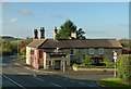
2
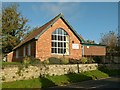
Croxton Kerrial Village Hall
On Main Street, below Middle Street.
Image: © Alan Murray-Rust
Taken: 7 Nov 2016
0.03 miles

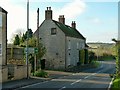
4
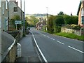
Main Street, Croxton Kerrial
Otherwise the A607 trunk road.
The presence of the milepost indicates that this was a turnpike road, in this instance linking Grantham and Melton Mowbray. The milepost is Listed Grade II and can be seen close up here http://www.geograph.org.uk/photo/5186968 .
Image: © Alan Murray-Rust
Taken: 7 Nov 2016
0.03 miles
5
The Peacock, Croxton Kerrial
A popular name for buildings, farms, roads and even a school round here. Something to do with Belvoir Castle, the local landowning estate, I do believe; the Duke of Rutland uses the bird as a logo for the commercial business.
(Taken on the 1,000th day of geograph.org.uk)
Image: © Kate Jewell
Taken: 1 Dec 2007
0.03 miles
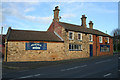
6
The Geese and Fountain, Croxton Kerrial
Formerly called The Peacock.
Unlike many modern local pub re-namings, this has a specific local identity. It refers to the flocks of geese resident in the village, http://www.geograph.org.uk/photo/69356 and the water spout alongside the main road http://www.geograph.org.uk/photo/30072 both of which feature in the sign above the entrance.
Image: © Alan Murray-Rust
Taken: 7 Nov 2016
0.03 miles
7
The Peacock, Main Street, Croxton Kerrial
This is the busy A607 Melton Mowbray to Grantham road. Even though there have been serious traffic calming measures carried out, including flashing slow down signs, the vehicles still thunder through here at over 30 miles per hour. The Peacock is the third building you come to on the way into the village from the Melton direction.
(Taken on the 1,000th day of geograph.org.uk)
Image: © Kate Jewell
Taken: 1 Dec 2007
0.03 miles
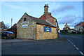
8
Hillside Farmhouse, Croxton Kerrial
Late 18th century farmhouse with later alterations, ironstone and limestone with pantiled roof, Listed Grade II.
Image: © Alan Murray-Rust
Taken: 7 Nov 2016
0.03 miles
9
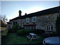
The Geese and Fountain
You can't get far from the sound of Geese in Croxton Kerrial, where they are farmed extensively. Now the pub is named for them.
It was, until quite recently, called The Peacock. See Image Image We have a photo with the current name from 2016 Image
Image: © Bob Harvey
Taken: 18 Nov 2018
0.03 miles
10
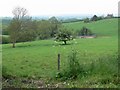
View towards the Vale of Belvoir
Looking northwest from the top of School Lane in Croxton Kerrial, Leicestershire.
Image: © Mat Fascione
Taken: 10 May 2008
0.04 miles