IMAGES TAKEN NEAR TO
Hillside Road, GRANTHAM, NG32 1NL
Introduction
This page details the photographs taken nearby to Hillside Road, NG32 1NL by members of the Geograph project.
The Geograph project started in 2005 with the aim of publishing, organising and preserving representative images for every square kilometre of Great Britain, Ireland and the Isle of Man.

There are currently over 7.5m images from over14,400 individuals and you can help contribute to the project by visiting https://www.geograph.org.uk
Image Map
Images are licensed for reuse under creativecommons.org/licenses/by-sa/2.0
Notes
- Clicking on the map will re-center to the selected point.
- The higher the marker number, the further away the image location is from the centre of the postcode.
Image Listing (43 Images Found)
Images are licensed for reuse under creativecommons.org/licenses/by-sa/2.0
Image
Details
Distance
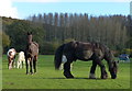
1
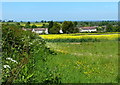
Farmland at Woolsthorpe By Belvoir
The houses are on Hillside Road.
Image: © Mat Fascione
Taken: 17 May 2014
0.01 miles
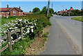
2
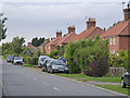
Sedgebrook Road, Woolsthorpe
The housing may be a local authority development but could have been provided by the Belvoir estate.
Image: © Alan Murray-Rust
Taken: 21 Aug 2013
0.07 miles
3
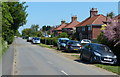
Houses along Sedgebrook Road, Woolsthorpe By Belvoir
Image: © Mat Fascione
Taken: 17 May 2014
0.07 miles
4
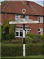
Fingerpost at Woolsthorpe
Note the initials KCC in the roundel, a reminder of the fact that Lincolnshire traditionally consisted of three separate county councils, this area being Kesteven.
Image: © Alan Murray-Rust
Taken: 21 Aug 2013
0.08 miles
5
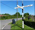
Fingerpost in Woolsthorpe By Belvoir
On the corner of Cliff Road and Sedgebrook Road.
Image: © Mat Fascione
Taken: 17 May 2014
0.08 miles
6
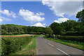
Cliff Road leaving Woolsthorpe by Belvoir
Starting to climb the escarpment ('cliff') at the south-east edge of the Vale of Belvoir.
Image: © Tim Heaton
Taken: 22 May 2020
0.09 miles

9
The Main Street in Woolsthorpe By Belvoir
Image: © Mat Fascione
Taken: 17 May 2014
0.09 miles
10
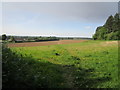
Footpath to Sedgebrook Road
The route can be clearly made out across the lower field.
The darkened sky is the result of a major fire at Langar Industrial Estate https://www.bbc.co.uk/news/uk-england-nottinghamshire-52757709
Image: © Jonathan Thacker
Taken: 21 May 2020
0.10 miles