IMAGES TAKEN NEAR TO
Manor Farm Cottages, Harston Road, GRANTHAM, NG32 1LN
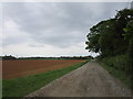
Introduction
This page details the photographs taken nearby to Manor Farm Cottages, Harston Road, NG32 1LN by members of the Geograph project.
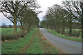
The Geograph project started in 2005 with the aim of publishing, organising and preserving representative images for every square kilometre of Great Britain, Ireland and the Isle of Man.

There are currently over 7.5m images from over14,400 individuals and you can help contribute to the project by visiting https://www.geograph.org.uk
Image Map
Images are licensed for reuse under creativecommons.org/licenses/by-sa/2.0
Notes
- Clicking on the map will re-center to the selected point.
- The higher the marker number, the further away the image location is from the centre of the postcode.
Image Listing (11 Images Found)
Images are licensed for reuse under creativecommons.org/licenses/by-sa/2.0
Image
Details
Distance
1
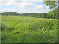
Farmland west of Denton
From the trackbed of the former Denton ironstone quarries branch line, looking south across rolling farmland to what was once the parkland of Denton Manor.
Image: © Trevor Rickard
Taken: 1 Jul 2012
0.11 miles
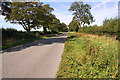
2
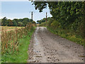
Farm track near Denton
This track leads to the large Denton Manor Farm.
Image: © Kate Jewell
Taken: 19 Oct 2005
0.15 miles
3
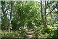
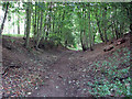
Former track bed of the Woolsthorpe Branch ironstone railway
Also marked as a 'Traffic-free cycle route' on the OS 1:25000 map, though parts of the track are narrow, with little headroom. For details of the former railway, see Image
Image: © Tim Heaton
Taken: 12 Aug 2022
0.17 miles
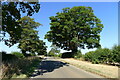
4
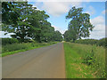
Belvoir Road
Running north-west and dead straight towards Woolsthorpe by Belvoir.
See Image .
Image: © Trevor Rickard
Taken: 1 Jul 2012
0.20 miles
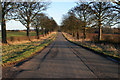
5
Belvoir Road near Denton
Looking towards Denton. This fine avenue of trees is an extension of the avenue leading to Belvoir Castle from the east entrance in Image
Image: © Kate Jewell
Taken: 14 Apr 2006
0.20 miles
8
Belvoir Road near Denton
Looking away from Belvoir Castle and towards Denton.
This tree lined road is an extension of the little used eastern entrance avenue to Belvoir Castle. The rise in the centre distance is the bridge over the old mineral railway, now part of the National Cycle Network, in the far south west corner of Image
Image: © Kate Jewell
Taken: 30 Jan 2010
0.22 miles
10
Trackbed of the Denton Branch
The Denton Branch, from Belvoir Junction on the Nottingham-Grantham line (SK832384) was built in the 1880s by the Great Northern Railway. It terminated north of the Denton-Harston road (SK847321), from where quarry-owned railways (originally narrow gauge, but standard gauge from 1948 until closure in 1974) led to opencast ironstone pits at Denton, Harston and Cedar Hill. In 1941 the railway to quarries at Harlaxton was built, from Casthorpe Junction (SK861343) to Gorse Lane (SK878308), via a reversing point at Swine Hill (SK886320). This photograph is taken looking towards the terminus from near the bridge under Belvoir Road. Here as elsewhere on the branch, a lot of trees have grown in the last 35 years. See other photos nearby for more on the ironstone railways in this area.
Image: © John Sutton
Taken: 27 Aug 2009
0.23 miles