IMAGES TAKEN NEAR TO
De Ligne Drive, GRANTHAM, NG32 1HZ
Introduction
This page details the photographs taken nearby to De Ligne Drive, NG32 1HZ by members of the Geograph project.
The Geograph project started in 2005 with the aim of publishing, organising and preserving representative images for every square kilometre of Great Britain, Ireland and the Isle of Man.

There are currently over 7.5m images from over14,400 individuals and you can help contribute to the project by visiting https://www.geograph.org.uk
Image Map
Images are licensed for reuse under creativecommons.org/licenses/by-sa/2.0
Notes
- Clicking on the map will re-center to the selected point.
- The higher the marker number, the further away the image location is from the centre of the postcode.
Image Listing (79 Images Found)
Images are licensed for reuse under creativecommons.org/licenses/by-sa/2.0
Image
Details
Distance
1
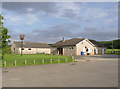
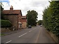
Harlaxton Sports and Social Club
A modern recreational facility on the east side of the village.
Image: © Alan Murray-Rust
Taken: 21 Aug 2013
0.09 miles
2
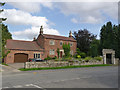
The Old Forge
Dated 1794 on a datestone http://www.geograph.org.uk/photo/3647078 above the central window. The garage extension is 20th century but well matched to the original house. Listed Grade II. The gateway at the right dates from the early 19th century - probably under Gregory Gregory - and is separately listed Grade II.
Image: © Alan Murray-Rust
Taken: 21 Aug 2013
0.11 miles
3
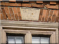
Datestone, 77 High Street
Showing the initials of George de Ligne Gregory and the date 1794. See http://www.geograph.org.uk/photo/3646118 for the house itself.
Image: © Alan Murray-Rust
Taken: 21 Aug 2013
0.11 miles
4
Village scene, Harlaxton
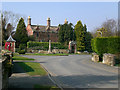
Lincolnshire is so rich in building stone that not many villages have a red-brick character. Most dwellings in Harlaxton, big or small, of whatever date, are of handsome red brick - often with stone detailing. The house shown here, 'Coneygree', is grander than most, but is typical of the character of the whole village. It dates, I believe, from the first half of the 19th century - probably the 1840's. (Does anybody know the origin of the name 'Coneygree'? Similar names, including 'Coneygier', are widespread in rural England. Something to do with rabbits? )
Coneygree stands overlooking this little green, which is somewhat of a focal point in the village plan. The obelisk has been identified by Richard Croft as Image
An interesting contrast to red-brick Harlaxton is to be found nearby at Denton (in SK8632), which is largely built of ironstone, so that yellow, green and rusty shades predominate.
Image: © Stefan Czapski
Taken: 21 Mar 2009
0.12 miles
5
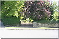
Entrance to #43 High Street
There is an OS benchmark Image on the stone at the base of the wall end on the right hand side of the entrance gateway
Image: © phil Richards
Taken: 13 Sep 2019
0.13 miles
6

2 Pond Street (aka Wyggeston Farm)
Built under George Gregory in the late 18th century and later remodelled. Listed Grade II. The garden wall is separately Listed Grade II for group value. It dates from the mid 19th century.
Image: © Alan Murray-Rust
Taken: 21 Aug 2013
0.13 miles
7
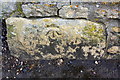
Benchmark on wall at entrance to #43 High Street
Ordnance Survey cut mark benchmark described on the Bench Mark Database at www.bench-marks.org.uk/bm111688
Image: © phil Richards
Taken: 13 Sep 2019
0.13 miles
9

Harlaxton moon
View of the church and university buildings from a layby on the A607.
Image: © Ian Paterson
Taken: 8 Apr 2009
0.14 miles