IMAGES TAKEN NEAR TO
Knipton, GRANTHAM, NG32 1EX
Introduction
This page details the photographs taken nearby to NG32 1EX by members of the Geograph project.
The Geograph project started in 2005 with the aim of publishing, organising and preserving representative images for every square kilometre of Great Britain, Ireland and the Isle of Man.

There are currently over 7.5m images from over14,400 individuals and you can help contribute to the project by visiting https://www.geograph.org.uk
Image Map
Images are licensed for reuse under creativecommons.org/licenses/by-sa/2.0
Notes
- Clicking on the map will re-center to the selected point.
- The higher the marker number, the further away the image location is from the centre of the postcode.
Image Listing (16 Images Found)
Images are licensed for reuse under creativecommons.org/licenses/by-sa/2.0
Image
Details
Distance
1
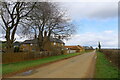
Belvoir Road passing Terrace Hills Farm
The 'terrace' refers to the top of the Leicestershire Wolds escarpment.
Image: © Tim Heaton
Taken: 15 Mar 2021
0.05 miles


6
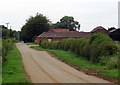
Entrance to Terrace Hills Farm on Belvoir Road
Image: © Andrew Tatlow
Taken: 26 Jun 2019
0.06 miles

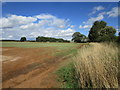
8
Terrace Hills Farm, near Branston, Leicestershire
Looking NW. This is the only group of buildings in this square. The farm sits on the flat land at the top of Terrace Hills. It can be quite blustery up here and there is a conifer windbreak planted from the road to the edge of the woodland that clothes the north slope of the Hills. These can be seen on the horizon and only just clip the corner of the square, mostly falling in the squares immediately to W, NW and N.
Image: © Kate Jewell
Taken: 9 Oct 2005
0.07 miles
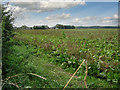
9

Public footpath to the village of Branston
Image: © Mat Fascione
Taken: 5 Jun 2010
0.13 miles
