IMAGES TAKEN NEAR TO
Knipton, GRANTHAM, NG32 1ES
Introduction
This page details the photographs taken nearby to NG32 1ES by members of the Geograph project.
The Geograph project started in 2005 with the aim of publishing, organising and preserving representative images for every square kilometre of Great Britain, Ireland and the Isle of Man.

There are currently over 7.5m images from over14,400 individuals and you can help contribute to the project by visiting https://www.geograph.org.uk
Image Map
Images are licensed for reuse under creativecommons.org/licenses/by-sa/2.0
Notes
- Clicking on the map will re-center to the selected point.
- The higher the marker number, the further away the image location is from the centre of the postcode.
Image Listing (24 Images Found)
Images are licensed for reuse under creativecommons.org/licenses/by-sa/2.0
Image
Details
Distance
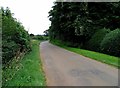
4
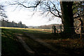
Farmland near Knipton
Part of the farmland owned by the Belvoir Castle Estate, this field is right on the edge of the featured square and drops steeply down to Knipton Reservoir in Image
Image: © Kate Jewell
Taken: 30 Jan 2008
0.06 miles
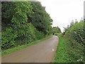
5
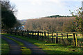
On the edge
Reservoir Cottage is right on the edge of the featured square and has stunning views to the west over Knipton Reservoir and Reservoir Wood, both in Image This is the view from the gate to the cottage.
Image: © Kate Jewell
Taken: 30 Jan 2008
0.07 miles
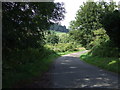
6
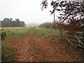
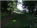
Farm track to Nursery Plantation
Misty November afternoon.
Image: © Jonathan Thacker
Taken: 16 Nov 2012
0.09 miles
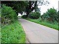
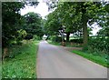
9
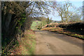
Branston Lane
This narrow country road joins Branston to Knipton. Just outside Branston it dip sharply only to climb steeply up the hill to the east of Knipton Reservoir. Here, just before it descends into Knipton, it is about 110 metres above sea level. The hill in the distance is on the edge of the Belvoir estate at about 130 metres.
Image: © Kate Jewell
Taken: 30 Jan 2008
0.13 miles