IMAGES TAKEN NEAR TO
Casthorpe, GRANTHAM, NG32 1DR
Introduction
This page details the photographs taken nearby to NG32 1DR by members of the Geograph project.
The Geograph project started in 2005 with the aim of publishing, organising and preserving representative images for every square kilometre of Great Britain, Ireland and the Isle of Man.

There are currently over 7.5m images from over14,400 individuals and you can help contribute to the project by visiting https://www.geograph.org.uk
Image Map
Images are licensed for reuse under creativecommons.org/licenses/by-sa/2.0
Notes
- Clicking on the map will re-center to the selected point.
- The higher the marker number, the further away the image location is from the centre of the postcode.
Image Listing (12 Images Found)
Images are licensed for reuse under creativecommons.org/licenses/by-sa/2.0
Image
Details
Distance
1
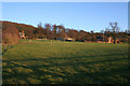
Casthorpe
Casthorpe is made up of a scattering of farms and a few houses at the foot of the Casthorpe Hills. Here, Casthorpe Lodge is in the centre with Lodge Cottage to the left. The newly converted barn to the right is called Casthorpe Grange.
Image: © Kate Jewell
Taken: 30 Jan 2010
0.04 miles
2
Footpath on Casthorpe Hill
The first part of this footpath follows the contours of Casthorpe Hills on its way past Casthorpe Lodge to the left.
Image: © Michael Patterson
Taken: 30 May 2006
0.06 miles
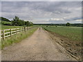
3
Approaching Casthorpe Hills
On the way to Barrowby and Grantham.
Image: © Kate Jewell
Taken: 30 Jan 2010
0.08 miles
4
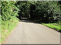
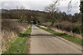
The Road Climbing Casthorpe Hill
Looking towards Barrowby, the road's destination.
Image: © William Fairbrother
Taken: 4 Sep 2012
0.08 miles

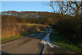
7
Going up Casthorpe Hills.
A 12% gradient through Casthorpe Covert.
Image: © Kate Jewell
Taken: 30 Jan 2010
0.14 miles
8
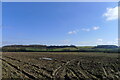
The Casthorpe Hills
The hills represent the western escarpment of the higher ground surrounding Barrowby and west Grantham, formed where harder Jurassic sandstones overly softer mudstones.
Image: © Tim Heaton
Taken: 9 Mar 2021
0.19 miles
9

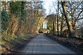
Casthorpe Road
Heading north east towards Barrowby.
Image: © JThomas
Taken: 21 Jun 2014
0.24 miles
