IMAGES TAKEN NEAR TO
Swine Hill, GRANTHAM, NG32 1AQ
Introduction
This page details the photographs taken nearby to Swine Hill, NG32 1AQ by members of the Geograph project.
The Geograph project started in 2005 with the aim of publishing, organising and preserving representative images for every square kilometre of Great Britain, Ireland and the Isle of Man.

There are currently over 7.5m images from over14,400 individuals and you can help contribute to the project by visiting https://www.geograph.org.uk
Image Map
Images are licensed for reuse under creativecommons.org/licenses/by-sa/2.0
Notes
- Clicking on the map will re-center to the selected point.
- The higher the marker number, the further away the image location is from the centre of the postcode.
Image Listing (18 Images Found)
Images are licensed for reuse under creativecommons.org/licenses/by-sa/2.0
Image
Details
Distance
1
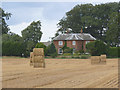
Wealdmore Lodge farmhouse
A fine Georgian farmhouse dating from 1803. Built as an estate farm by George de Ligne Gregory, lord of the manor of Harlaxton. It is Listed Grade II as are various outbuildings of the period which are unique survivors.
Image: © Alan Murray-Rust
Taken: 11 Aug 2013
0.01 miles
2
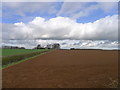
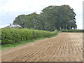
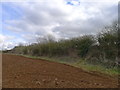
Looking across fields to Wealdmore Lodge Farm
The red soil testifies to the iron-rich nature of the bedrock, see Image
Image: © Tim Heaton
Taken: 1 Mar 2017
0.01 miles
3
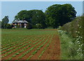
Farmland next to Wealdmore Lodge Farm
Looking towards the Grade II Listed Georgian (1803) Wealdmore Lodge Farmhouse.
Image: © Mat Fascione
Taken: 17 May 2014
0.01 miles
4
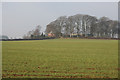
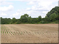
Farmland near Grantham
Wealdmore Lodge Farm is the only building in this square. It sits at the top of Swine Hill.
Image: © Kate Jewell
Taken: 28 Jan 2006
0.04 miles
5
Footpath to Harlaxton
This follows the line of the hedge before skirting the stand of trees at Wealdmore Lodge. The slight ridge running across the lines of the stubble mark the line of the railway which served the Harlaxton Quarry system, giving access to the later quarries in the area between Stroxton and Harlaxton Manor.
Image: © Alan Murray-Rust
Taken: 11 Aug 2013
0.11 miles
6
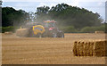
Baling in a cloud of dust
In fields adjacent to Wealdmore Lodge.
Image: © Alan Murray-Rust
Taken: 11 Aug 2013
0.13 miles
7
Former Ironstone Quarry
This was No.1 or Pearsons Quarry of the Harlaxton Quarries system, and was worked from 1943 to 1951. The extent of extraction can be seen from the difference in level between the field and the road which runs at the top of the bank in the background.
Image: © Alan Murray-Rust
Taken: 11 Aug 2013
0.19 miles
8
Former ironstone quarry
This was, from 1943-61, Harlaxton No 1 (Pearson's) Quarry. Ore extraction has left the fields lower than Gorse Lane, whose hedge crosses the picture. The trees in the distance on the right are Tollbar Plantation, behind which the Harlaxton system had its engine sheds, workshops and sidings. The concrete foundations of the engine shed are still there (SK878309). This picture is taken from where the railway crossed the Swine Hill road on its way to No 3 (Swine Hill) quarry. See other photos nearby for more on the Harlaxton quarries and railways.
Image: © John Sutton
Taken: 27 Aug 2009
0.20 miles
10
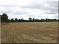
Footpath ladder exit from field
The area has been strip-mined for ironstone, leaving the surface of the field several feet below the road.
Image: © Tim Heaton
Taken: 1 Mar 2017
0.23 miles