IMAGES TAKEN NEAR TO
Ruscombe Place, NOTTINGHAM, NG3 1PD
Introduction
This page details the photographs taken nearby to Ruscombe Place, NG3 1PD by members of the Geograph project.
The Geograph project started in 2005 with the aim of publishing, organising and preserving representative images for every square kilometre of Great Britain, Ireland and the Isle of Man.

There are currently over 7.5m images from over14,400 individuals and you can help contribute to the project by visiting https://www.geograph.org.uk
Image Map
Images are licensed for reuse under creativecommons.org/licenses/by-sa/2.0
Notes
- Clicking on the map will re-center to the selected point.
- The higher the marker number, the further away the image location is from the centre of the postcode.
Image Listing (72 Images Found)
Images are licensed for reuse under creativecommons.org/licenses/by-sa/2.0
Image
Details
Distance
1
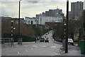
Abbotsford Drive
Looking towards the City Centre, with the Victoria Centre flats on the skyline. This road was created from scratch as part of the St Anns redevelopment of the 1970s and is a main feeder road for the area.
Image: © Alan Murray-Rust
Taken: 8 Mar 2009
0.10 miles
2
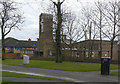
Parish Church of St Ann and Emmanuel
Anglican parish church built as part of the redevelopment of the St Anns area and opened in 1974. On Robin Hood Chase.
Image: © Alan Murray-Rust
Taken: 8 Mar 2009
0.12 miles
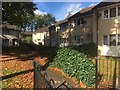
4

Chasewood baptist Church
Not recognised on the 1:50000 map, although it does feature on the 1:25000
Image: © Alan Murray-Rust
Taken: 8 Mar 2009
0.12 miles
5
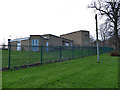
Chasewood Baptist Church
An uninspiring modern building, looking much as it did eleven years ago Image
Image: © Stephen Craven
Taken: 18 Jan 2020
0.13 miles
6
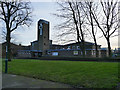
Church of St Ann with Emmanuel, Nottingham
The original St Ann's church, which was on St Ann's Well Road, opened in 1864, succeeding an earlier mission chapel. It closed at Easter 1971 and the present building opened the following year (source: http://southwellchurches.nottingham.ac.uk/nottingham-st-ann/hhistory.php ). Emmanuel church on Woodborough Road closed about the same time and the new church took both names (from Wikipedia).
The architect was probably Gordon Smith, who certainly designed other churches in similar style at this period, and is still recorded on the Church Heritage Record as the inspecting architect for St Ann's.
Image: © Stephen Craven
Taken: 18 Jan 2020
0.13 miles
7
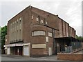
Former Cinema, St. Ann's Well Road
Numerous cinemas were built around Nottingham in the 1930s. Only one survives as a cinema: the Savoy on Derby Road. Others have a variety of uses: churches, offices or retail outlets.
Image: © SK53
Taken: 26 Apr 2011
0.13 miles
8
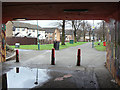
Robin Hood Chase
Looking down from the subway under Abbotsford Drive
Image: © Alan Murray-Rust
Taken: 8 Mar 2009
0.13 miles
9
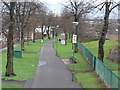
Looking down Robin Hood Chase
From the Abbotsford Drive bridge.
Image: © Alan Murray-Rust
Taken: 8 Mar 2009
0.13 miles
10
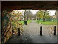
Robin Hood Chase, looking south from Abbotsford Drive Subway
Very little change from my 2009 view https://www.geograph.org.uk/photo/1197199 ; the parked rental scooter is the most significant indicator of the passing years!
Robin Hood Chase is part of the sequence of walks opened in 1851 marking the then newly incorporated city inclosures.
Image: © Alan Murray-Rust
Taken: 27 Nov 2022
0.13 miles