1
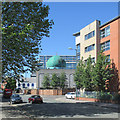
Seventh Day Adventist church, Lamartine Street
A functional modern building.
Image: © Stephen Craven
Taken: 18 Jan 2020
0.10 miles
2
St Ann's Inn, St Ann's Nottingham
A fairly typical Nottingham 1970s/1980s estate pub. Built as part of the re-development of the St. Ann's area in the 1970s.
Image: © SK53
Taken: 26 Apr 2011
0.10 miles
3
Benchmark on end of wall on St Anns Well Road
Ordnance Survey cut mark benchmark described on the Bench Mark Database at http://www.bench-marks.org.uk/bm47852
Image: © Roger Templeman
Taken: 30 Mar 2013
0.11 miles
4
Curzon Gardens
Image: © David Lally
Taken: 6 Oct 2017
0.12 miles
5
Across St Ann's
Houses like these replaced the Victorian terraces of the St Ann's district in the 1970s, the City Council learning from the mistaken deck-access flats experiment of the 1960s (the flats at Balloon Wood, Old Basford and Hyson Green were demolished by the early 1980s and replaced by low-density housing). St Andrew's Church on Mansfield Road shows on the skyline, above the large textile factory on St Ann's Hill Road.
Image: © John Sutton
Taken: 30 Jun 2015
0.12 miles
6
Christ Citadel Christian Centre, St Anns Well Road
There is an OS benchmark
Image on the road face end of the brick wall which forms the northern boundary of the site
Image: © Roger Templeman
Taken: 30 Mar 2013
0.12 miles
7
Christ Citadel Christian Centre, St Ann's Well Road
Formerly St Catharine's (Church of England) from 1896 to 2003, it had its own cemetery behind the church building which is now confusingly known as St Mary's Rest Garden. Architect Robert Charles Clarke. (source: Wikipedia)
Image: © Stephen Craven
Taken: 18 Jan 2020
0.12 miles
8
Nottingham Central Mosque, Curzon Street
The mosque opened in 1992 and has subsequently been extended.
Image: © Stephen Craven
Taken: 18 Jan 2020
0.12 miles
9
St Ann's Well Road: Nurani Jami Masjid
A large mosque on the corner of St Ann's Well Road and Curzon Street.
Image: © John Sutton
Taken: 30 Jun 2015
0.13 miles
10
Nottingham - NG3 (St Ann's)
The mosque with a Gala Bingo Hall beyond it (i.e. the white building), as one looks towards Beck Street and the A60.
Image: © David Hallam-Jones
Taken: 7 May 2012
0.13 miles


