IMAGES TAKEN NEAR TO
Truman Close, NOTTINGHAM, NG3 1NL
Introduction
This page details the photographs taken nearby to Truman Close, NG3 1NL by members of the Geograph project.
The Geograph project started in 2005 with the aim of publishing, organising and preserving representative images for every square kilometre of Great Britain, Ireland and the Isle of Man.

There are currently over 7.5m images from over14,400 individuals and you can help contribute to the project by visiting https://www.geograph.org.uk
Image Map
Images are licensed for reuse under creativecommons.org/licenses/by-sa/2.0
Notes
- Clicking on the map will re-center to the selected point.
- The higher the marker number, the further away the image location is from the centre of the postcode.
Image Listing (134 Images Found)
Images are licensed for reuse under creativecommons.org/licenses/by-sa/2.0
Image
Details
Distance
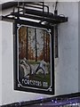
1
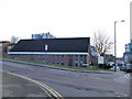
St Ann's Inn, St Ann's Nottingham
A fairly typical Nottingham 1970s/1980s estate pub. Built as part of the re-development of the St. Ann's area in the 1970s.
Image: © SK53
Taken: 26 Apr 2011
0.05 miles
2
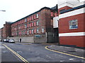
Nottingham - NG3
The former premises of Harrison Co. Ltd, lace dressers, on Great Freeman Street (off the Huntingdon Street on the fringe of the city centre). It is currently used as a new stock warehouse by Hopewells, the up-market furniture retailer.
Image: © David Hallam-Jones
Taken: 21 Apr 2012
0.12 miles
3
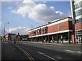
Hopewells, Huntingdon Street
This rather eccentric piece of architecture houses a home furniture shop and is adorned with a very minimalistic clock.
Image: © Richard Vince
Taken: 28 Jun 2012
0.13 miles
4
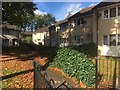
Seventh Day Adventist church, Lamartine Street
A functional modern building.
Image: © Stephen Craven
Taken: 18 Jan 2020
0.14 miles
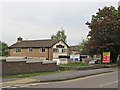
5
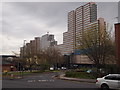
Nottingham - NG1
The dwarfed cream-coloured "New Foresters" pub now sits at the side of the pedestrianised St Ann's Street. In the foreground a semi-circular branch of the A60 sweeps out to rejoin Huntingdon Street again as part of a one-way traffic system. Overshadowing these two "green" islands a handful of specimens of post-modern architecture loom in the background.
Image: © David Hallam-Jones
Taken: 21 Apr 2012
0.14 miles
7
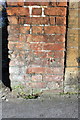
Benchmark on end of wall on St Anns Well Road
Ordnance Survey cut mark benchmark described on the Bench Mark Database at http://www.bench-marks.org.uk/bm47852
Image: © Roger Templeman
Taken: 30 Mar 2013
0.14 miles
8
Glasshouse / Huntingdon Street, Nottingham
The north- and southbound arms of the A60 rejoin here. The hoardings on the left surround the Victoria Works. Across Huntingdon Street is The Glasshouse, with retail units and flats.
Image: © Derek Harper
Taken: 11 Oct 2014
0.15 miles
9
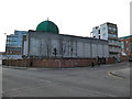
Nottingham Central Mosque, Curzon Street
The mosque opened in 1992 and has subsequently been extended.
Image: © Stephen Craven
Taken: 18 Jan 2020
0.15 miles