1
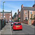
Robin Hood Terrace
Looking north towards Harcourt Terrace and Lamartine Street. Robin Hood Terrace is a Grade II listed row built in the 1860s in the pleasingly plain style of the mid century - see http://www.britishlistedbuildings.co.uk/en-458530-1-to-20-robin-hood-terrace-#.VZWfDSiwHZY .
Image: © John Sutton
Taken: 30 Jun 2015
0.01 miles
2
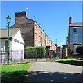
The north end of Robin Hood Terrace
Restored in the 1980s this is a Grade II listed row built in the 1860s in the pleasingly plain style of the mid century - see http://www.britishlistedbuildings.co.uk/en-458530-1-to-20-robin-hood-terrace-#.VZWfDSiwHZY .
Image: © John Sutton
Taken: 30 Jun 2015
0.01 miles
3
Robin Hood Terrace and Harcourt Terrace
Robin Hood Terrace (ahead, left) dates from the middle of the nineteenth century, the two-storey houses on Harcourt and Foljambe Terraces from later in the Victorian period.
Image: © John Sutton
Taken: 16 Aug 2016
0.02 miles
4
The south end of Robin Hood Terrace
Looking towards Victoria Park on a sunny August morning. This is a Grade II listed row built in the 1860s in the pleasingly plain style of the mid century - see http://www.britishlistedbuildings.co.uk/en-458530-1-to-20-robin-hood-terrace-#.VZWfDSiwHZY . For a view in the other direction, see
Image
Image: © John Sutton
Taken: 22 Aug 2015
0.03 miles
5
Harcourt Terrace
Looking from the Lamartine Street end towards Robin Hood Terrace on a bright June morning.
Image: © John Sutton
Taken: 30 Jun 2015
0.03 miles
6
Victoria Park and Promenade
A bright Saturday morning in August. For closer views of the houses, see
Image] and
Image
Image: © John Sutton
Taken: 22 Aug 2015
0.03 miles
7
Nottingham - NG3 (Sneinton)
These buildings situated within the old boundary wall of Victoria Park and alongside a path that connects Robin Hood Terrace with Bath Street are currently used by the Sneinton Jehovah Witnesses Church. Were these premises previously used as a municipal nursery, a baby clinic or something similar ?
Image: © David Hallam-Jones
Taken: 7 May 2012
0.03 miles
8
Robin Hood Terrace, Promenade and an entrance to Victoria Park
Two Grade II listed rows, seen on a bright June morning. Built c 1860 they were part of the Borough's initial expansion beyond its mediaeval core after the Enclosure Act of 1845. For the listings see http://www.britishlistedbuildings.co.uk/en-458530-1-to-20-robin-hood-terrace-#.VZWfDSiwHZY and http://www.britishlistedbuildings.co.uk/en-458900-1-to-30-the-promenade-#.VZWdNCiwHZY .
Image: © John Sutton
Taken: 30 Jun 2015
0.03 miles
9
Victoria Park, Sneinton, Nottingham
This church, separated by a footpath that links Bath Street - behind the photographer - and Harcourt Terrace - at the rear of the church, looks out onto Victoria Park. The brightly coloured houses are on another footpath named "Promenade".
Image: © David Hallam-Jones
Taken: 10 Jan 2015
0.03 miles
10
Victoria Park, Promenade
Image: © Bryn Holmes
Taken: 16 Mar 2020
0.04 miles


