1
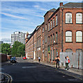
Roden Street
Looking towards Robin Hood Street on a bright Saturday morning in late August. The former mill at the far end of the street has been converted into flats, but the factory building nearer the camera appeared derelict.
Image: © John Sutton
Taken: 22 Aug 2015
0.05 miles
2
William Bancroft Building
This former mill is not listed and is now converted into housing. Not been able to find out who William Bancroft is (or was).
June 2016: My thanks go to Chris Allen for finding a reference to "William Bancroft & Co, blouse manufacturers Nottingham" in the Nottinghamshire archives.
Image: © David Lally
Taken: 30 Apr 2016
0.05 miles
3
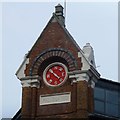
Date stone and weather vane dial
Image: © David Lally
Taken: 30 Apr 2016
0.05 miles
4
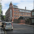
Bancroft Buildings, Robin Hood Street, Nottingham
Formerly William Windley's silk factory, dated 1869 in the gable (
Image]). See also
Image
Converted to flats in 2003.
Image: © Stephen Richards
Taken: 19 Jun 2015
0.05 miles
5
William Bancroft Buildings, Robin Hood Street
Image: © Bryn Holmes
Taken: 16 Mar 2020
0.05 miles
6
Nottingham - NG3 (Sneinton)
This former mill (clothing factory) on the corner of Robin Hood Street and Roden Street, as seen across Victoria Park, has been converted into apartments. It is now called The William Bancroft Building but may well have been known as Bancroft/s Mill or Roden/s Mill in the past?
Image: © David Hallam-Jones
Taken: 7 May 2012
0.06 miles
7
Robin Hood Street: former factory
Bancroft Buildings, a grand silk factory fronting Robin Hood Street and Roden Street, flats since 2003. It was built in 1869 for William Windley. Like many lace and cotton factories in the East Midlands it had many-windowed attic workshops where much of the finest work was done, in the most favourable light. The red clock face on the corner gable is a weather vane, marked with the points of the compass instead of numbers.
Image: © John Sutton
Taken: 22 Aug 2015
0.06 miles
8
Paxton Gardens, St Ann's
Paxton Gardens leads off Stonebridge Road. This area was comprehensively redeveloped in the 1960s and '70s when vast numbers of 19th century houses, built for the working poor and widely condemned as slums, were demolished.
Image: © Stephen McKay
Taken: 16 Oct 2022
0.07 miles
9
Paxton Gardens, St Ann's
The modern St Ann's, a large Nottingham inner city social housing area, is a good example of a Radburn estate - a design that was very fashionable from the 1960s to the 1980s. The idea was to ruthlessly separate cars and pedestrians so that all the houses face on to walkways and cars are kept on access roads behind walls at the rear. In this view rows of terraced houses look out on to a grassed patch with mature trees perhaps intended to emulate a village green. It does not look unpleasant on a sunny morning but experience with Radburn estates in general suggests that the confusing layout with myriad cut throughs and paths (and parking areas hidden from view) is unpopular and encourages crime. St Ann's was comprehensively redeveloped in the 1970s after the previous housing stock of poor quality 19th century terraced houses - specifically built for the working poor - was demolished.
Image: © Stephen McKay
Taken: 16 Oct 2022
0.08 miles
10
Nottingham - NG3 (Sneinton)
"The Vine" - on the corner of Liverpool Street and Handel Street - is one of the last remaining pubs in Nottingham with a curved corner-entrance door opening directly onto the street. The Home Brewery Company of Arnold purchased it in 1896 when it also boasted stables and a smithy. Although the facilities and internal decor remains very basic, the pub is still functioning at a time when many other pubs in Sneinton have closed.
Image: © David Hallam-Jones
Taken: 12 May 2012
0.08 miles


