IMAGES TAKEN NEAR TO
Rodel Court, NOTTINGHAM, NG3 1DZ
Introduction
This page details the photographs taken nearby to Rodel Court, NG3 1DZ by members of the Geograph project.
The Geograph project started in 2005 with the aim of publishing, organising and preserving representative images for every square kilometre of Great Britain, Ireland and the Isle of Man.

There are currently over 7.5m images from over14,400 individuals and you can help contribute to the project by visiting https://www.geograph.org.uk
Image Map
Images are licensed for reuse under creativecommons.org/licenses/by-sa/2.0
Notes
- Clicking on the map will re-center to the selected point.
- The higher the marker number, the further away the image location is from the centre of the postcode.
Image Listing (101 Images Found)
Images are licensed for reuse under creativecommons.org/licenses/by-sa/2.0
Image
Details
Distance
1
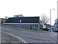
Seventh Day Adventist church, Lamartine Street
A functional modern building.
Image: © Stephen Craven
Taken: 18 Jan 2020
0.05 miles
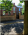
2
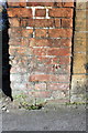
Benchmark on end of wall on St Anns Well Road
Ordnance Survey cut mark benchmark described on the Bench Mark Database at http://www.bench-marks.org.uk/bm47852
Image: © Roger Templeman
Taken: 30 Mar 2013
0.07 miles
3
Across St Ann's
Houses like these replaced the Victorian terraces of the St Ann's district in the 1970s, the City Council learning from the mistaken deck-access flats experiment of the 1960s (the flats at Balloon Wood, Old Basford and Hyson Green were demolished by the early 1980s and replaced by low-density housing). St Andrew's Church on Mansfield Road shows on the skyline, above the large textile factory on St Ann's Hill Road.
Image: © John Sutton
Taken: 30 Jun 2015
0.08 miles
4
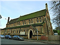
Christ Citadel Christian Centre, St Ann's Well Road
Formerly St Catharine's (Church of England) from 1896 to 2003, it had its own cemetery behind the church building which is now confusingly known as St Mary's Rest Garden. Architect Robert Charles Clarke. (source: Wikipedia)
Image: © Stephen Craven
Taken: 18 Jan 2020
0.08 miles
5
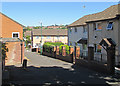
Christ Citadel Christian Centre, St Anns Well Road
There is an OS benchmark Image on the road face end of the brick wall which forms the northern boundary of the site
Image: © Roger Templeman
Taken: 30 Mar 2013
0.08 miles
6

Plantaganet Street
A street of the 1850s, established as the Borough of Nottingham expanded beyond its mediaeval core. To the left is the central gable of Image
Image: © John Sutton
Taken: 30 Jun 2015
0.09 miles
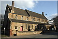
7
Plantaganet Street: The Working Man's Retreat
George Gill (1778-1855) was a philanthropist whose interests lay in education and the welfare of the elderly. He founded the People's College and built The Working Man's Retreat (retirement dwellings for the deserving) in 1852. It is in the satisfyingly plain style of many Nottingham buildings of the middle years of the nineteenth century, but not a listed building. The picture was taken against the light on a very sunny morning in late June.
Image: © John Sutton
Taken: 30 Jun 2015
0.09 miles
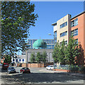
8
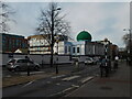
Nottingham - NG3 (St Ann's)
The mosque with a Gala Bingo Hall beyond it (i.e. the white building), as one looks towards Beck Street and the A60.
Image: © David Hallam-Jones
Taken: 7 May 2012
0.09 miles
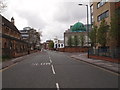
9
St Ann's Well Road: Nurani Jami Masjid
A large mosque on the corner of St Ann's Well Road and Curzon Street.
Image: © John Sutton
Taken: 30 Jun 2015
0.10 miles
10
St Ann's Well Road, Nottingham city centre
Image: © Bryn Holmes
Taken: 16 Mar 2020
0.10 miles