IMAGES TAKEN NEAR TO
Belton Lane, GRANTHAM, NG31 9PG
Introduction
This page details the photographs taken nearby to Belton Lane, NG31 9PG by members of the Geograph project.
The Geograph project started in 2005 with the aim of publishing, organising and preserving representative images for every square kilometre of Great Britain, Ireland and the Isle of Man.

There are currently over 7.5m images from over14,400 individuals and you can help contribute to the project by visiting https://www.geograph.org.uk
Image Map
Images are licensed for reuse under creativecommons.org/licenses/by-sa/2.0
Notes
- Clicking on the map will re-center to the selected point.
- The higher the marker number, the further away the image location is from the centre of the postcode.
Image Listing (62 Images Found)
Images are licensed for reuse under creativecommons.org/licenses/by-sa/2.0
Image
Details
Distance
1
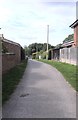
Harrowby Mill Lane
This is the lane with the sign at Image
Image: © Bob Harvey
Taken: 5 Sep 2020
0.02 miles
2
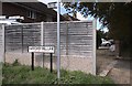
A footpath and a private drive
The sign is for Harrowby Mill Lane, but clearly says it is not a public road.
Image: © Bob Harvey
Taken: 5 Sep 2020
0.02 miles
3
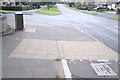
Tactile paving
The two directions of the ribs in the surface denote a footway and a cycleway in turn. The footpath along Belton Lane has been divided to provide off-road cycling.
Image: © Bob Harvey
Taken: 5 Sep 2020
0.02 miles
4
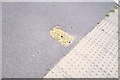
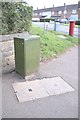
Fire hydrant cover
The cover described by the sign in Image If that's 3.8 metres, I am 1-and-a-half feet tall.
The tactile paving is in the footpath of Belton lane, leading to the kerbside
Image: © Bob Harvey
Taken: 5 Sep 2020
0.02 miles
5
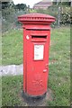
A Pillar box
At the corner of Princess Avenue and Belton Lane. An EIIR box
Image: © Bob Harvey
Taken: 5 Sep 2020
0.02 miles
6
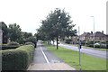
Dual purpose path on Belton Lane
The footpath on the left, the cycle path on the right.
note the different tactile paving for the two
Image: © Bob Harvey
Taken: 5 Sep 2020
0.02 miles
7
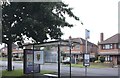
Bus shelter on Belton Lane
Bearing the arms of SKDC, which doubles round here as the town council. This stop is currently only served by the limited Number 1 town route. it is named "Royal Queen PH" after the adjacent pub.
Image: © Bob Harvey
Taken: 5 Sep 2020
0.02 miles
8
Telephone cabinet
The wires from that manhole in front are laid into termination frames inside that cubicle. It's not an active cubicle, it contains no electronics for fibre optics. Its too old, and has no ventilation louvres.
In the distance is Image If the box were transparent, you could see Image
Image: © Bob Harvey
Taken: 5 Sep 2020
0.03 miles
9
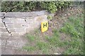
Hydrant sign
A transitional hydrant - 127 it says. That's a 5 inch pipe, but decribed in metric. 3.8 metres to the hydrant. A bit of surplus precision, there. They don't do that on more recent ones.
A sign from the years when we metricated.
Image: © Bob Harvey
Taken: 5 Sep 2020
0.03 miles
10
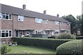
Postwar terrace
Possibly as late as the late 1960s. A plain architecture with concrete lintels and cantilevered porches, but large windows
Image: © Bob Harvey
Taken: 5 Sep 2020
0.03 miles