IMAGES TAKEN NEAR TO
Turnor Road, GRANTHAM, NG31 9ET
Introduction
This page details the photographs taken nearby to Turnor Road, NG31 9ET by members of the Geograph project.
The Geograph project started in 2005 with the aim of publishing, organising and preserving representative images for every square kilometre of Great Britain, Ireland and the Isle of Man.

There are currently over 7.5m images from over14,400 individuals and you can help contribute to the project by visiting https://www.geograph.org.uk
Image Map
Images are licensed for reuse under creativecommons.org/licenses/by-sa/2.0
Notes
- Clicking on the map will re-center to the selected point.
- The higher the marker number, the further away the image location is from the centre of the postcode.
Image Listing (9 Images Found)
Images are licensed for reuse under creativecommons.org/licenses/by-sa/2.0
Image
Details
Distance
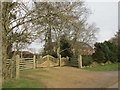
2
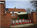
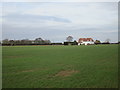
A pair of Land Settlement Association houses
59 smallholdings for redundant Durham miners were established at Harrowby by the Land Settlement Association in 1935. All were sold off in 1971 and most of the houses have been altered and the land incorporated into neighbouring farms.
This pair of houses have been altered and extended to the point of being almost unrecognisable.
Image: © Jonathan Thacker
Taken: 8 Feb 2018
0.01 miles
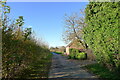
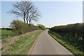
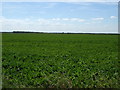
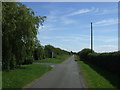
3
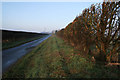
Turnor Road
The land to the left is on the edge of the disused Spittlegate Airfield and belongs to the Ministry of Defence, see Image The Territorial Army uses this area for training. The land on the right is Image
Image: © Kate Jewell
Taken: 18 Feb 2007
0.04 miles
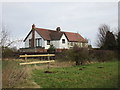
5
Former Land Settlement Association smallholding
59 smallholdings for redundant Durham miners were established at Harrowby by the Land Settlement Association in 1935. All were sold off in 1971 and most of the houses have been altered and the land incorporated into neighbouring farms.
This is now unrecognisable for what it once was - a pair of small semi-detached houses.
Image: © Jonathan Thacker
Taken: 8 Feb 2018
0.14 miles
6
Land Settlement Association houses
Much altered.
59 smallholdings were established for redundant Durham miners at Harrowby by the Land Settlement Association. Most consisted of a semi-detached house and about five acres of land. All were sold off in 1971 and much of the land has been incorporated into neighbouring farms. https://en.wikipedia.org/wiki/Land_Settlement_Association
Image: © Jonathan Thacker
Taken: 8 Feb 2018
0.15 miles
9
Single Land Settlement Association House
59 smallholdings for redundant Durham miners were established at Harrowby by the Land Settlement Association in 1935. All were sold off in 1971 and most of the houses have been altered and the land incorporated into neighbouring farms. Most were semi-detached houses but some were single dwellings as here.
Image: © Jonathan Thacker
Taken: 8 Feb 2018
0.25 miles