IMAGES TAKEN NEAR TO
Ryde Avenue, GRANTHAM, NG31 7DY
Introduction
This page details the photographs taken nearby to Ryde Avenue, NG31 7DY by members of the Geograph project.
The Geograph project started in 2005 with the aim of publishing, organising and preserving representative images for every square kilometre of Great Britain, Ireland and the Isle of Man.

There are currently over 7.5m images from over14,400 individuals and you can help contribute to the project by visiting https://www.geograph.org.uk
Image Map
Images are licensed for reuse under creativecommons.org/licenses/by-sa/2.0
Notes
- Clicking on the map will re-center to the selected point.
- The higher the marker number, the further away the image location is from the centre of the postcode.
Image Listing (10 Images Found)
Images are licensed for reuse under creativecommons.org/licenses/by-sa/2.0
Image
Details
Distance
1

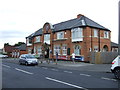
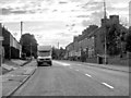
Post office and supermarket
On Dysart Road.
Image: © JThomas
Taken: 21 Jun 2014
0.08 miles
2
The Prior(y) pub, Earlesfield
Although the right hand sign shows the name as "The Prior", the pub is actually called "The Priory" - the "Y" seems to have fallen off at some stage. Signage was then changed sometime in the following year as documented in - Image]
Image: © JThomas
Taken: 17 Aug 2013
0.08 miles

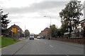
4
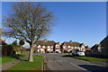
Goodliff Road approaching Dysart Road, Grantham
Was Dysart Road named after William Tollemache, 9th Earl of Dysart? And Goodliff Road?
Image: © Tim Heaton
Taken: 9 Mar 2021
0.10 miles
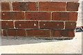
5
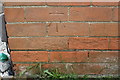
Benchmark on #203 Dysart Road
Ordnance Survey cut mark benchmark described on the Bench Mark Database at www.bench-marks.org.uk/bm107332
Image: © Roger Templeman
Taken: 7 May 2019
0.11 miles
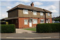
6
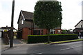
Nos. 203 and 205 Dysart Road
There is an OS benchmark Image on the front of the left hand house at its left hand corner
Image: © Roger Templeman
Taken: 7 May 2019
0.12 miles
9
Benchmark on #13 The Avenue
Ordnance Survey cut mark benchmark described on the Bench Mark Database at www.bench-marks.org.uk/bm107333
Image: © Roger Templeman
Taken: 7 May 2019
0.19 miles
10
#13 The Avenue and #10 The Grove
There is an OS benchmark Image on the near corner, left hand face, of the left hand house
Image: © Roger Templeman
Taken: 7 May 2019
0.19 miles