IMAGES TAKEN NEAR TO
Stamford Street, GRANTHAM, NG31 7BP
Introduction
This page details the photographs taken nearby to Stamford Street, NG31 7BP by members of the Geograph project.
The Geograph project started in 2005 with the aim of publishing, organising and preserving representative images for every square kilometre of Great Britain, Ireland and the Isle of Man.

There are currently over 7.5m images from over14,400 individuals and you can help contribute to the project by visiting https://www.geograph.org.uk
Image Map
Images are licensed for reuse under creativecommons.org/licenses/by-sa/2.0
Notes
- Clicking on the map will re-center to the selected point.
- The higher the marker number, the further away the image location is from the centre of the postcode.
Image Listing (34 Images Found)
Images are licensed for reuse under creativecommons.org/licenses/by-sa/2.0
Image
Details
Distance
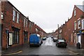
1
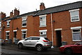
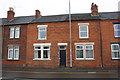
Victoria Street houses
There is an OS Benchmark Image on the bricks at the left hand side of the alleyway between the two parked cars
Image: © phil Richards
Taken: 9 Sep 2019
0.04 miles
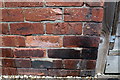
2
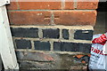
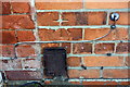
Benchmark on No. 66 Victoria Street
Ordnance Survey cut mark benchmark described on the Bench Mark Database at www.bench-marks.org.uk/bm111448
Image: © phil Richards
Taken: 9 Sep 2019
0.06 miles
3
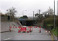
Railway underpass
The traffic lights say GO but there is a slight problem!
Image: © Andrew Tatlow
Taken: 19 Apr 2006
0.07 miles
4
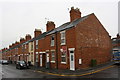
Victoria Street houses at Stamford Street junction
There is an OS benchmark Image on the side of the nearest house next to a wooden fence panel at the right hand edge of the image
Image: © phil Richards
Taken: 9 Sep 2019
0.08 miles
5
Benchmark on #161 Victoria Street
Ordnance Survey cut mark benchmark described on the Bench Mark Database at www.bench-marks.org.uk/bm111449
Image: © phil Richards
Taken: 9 Sep 2019
0.08 miles
6
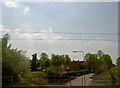
The A607 going under the East Coast Main railway line
Taken from a train heading North and slowing for Grantham station.
Image: © Steve Fareham
Taken: 8 May 2008
0.12 miles
7
Victoria Street
Bricked up windows at the corner shop and barred windows opposite.
Image: © Andrew Tatlow
Taken: 19 Apr 2006
0.12 miles
8
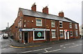
Sandwich Bar at junction of Victoria Street and Springfield Road
Image: © Roger Templeman
Taken: 9 Sep 2019
0.14 miles
9
No. 43 Springfield Road
There is an OS benchmark Image on the front of the house at its junction with the house to its left
Image: © phil Richards
Taken: 9 Sep 2019
0.16 miles
10
Benchmark on #43 Springfield Road
Ordnance Survey cut mark benchmark described on the Bench Mark Database at www.bench-marks.org.uk/111447
Image: © phil Richards
Taken: 9 Sep 2019
0.16 miles