IMAGES TAKEN NEAR TO
Huntingtower Road, GRANTHAM, NG31 7AY
Introduction
This page details the photographs taken nearby to Huntingtower Road, NG31 7AY by members of the Geograph project.
The Geograph project started in 2005 with the aim of publishing, organising and preserving representative images for every square kilometre of Great Britain, Ireland and the Isle of Man.

There are currently over 7.5m images from over14,400 individuals and you can help contribute to the project by visiting https://www.geograph.org.uk
Image Map
Images are licensed for reuse under creativecommons.org/licenses/by-sa/2.0
Notes
- Clicking on the map will re-center to the selected point.
- The higher the marker number, the further away the image location is from the centre of the postcode.
Image Listing (129 Images Found)
Images are licensed for reuse under creativecommons.org/licenses/by-sa/2.0
Image
Details
Distance
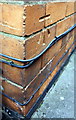
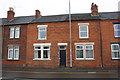
1
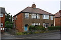
Nos. 141 and 139 Huntingtower Road
There is an Ordnance Survey benchmark Image on the left hand side of the left hand house near its front corner
Image: © phil Richards
Taken: 9 Sep 2019
0.00 miles
2
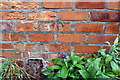
Damaged benchmark on #141 Huntingtower Road
Ordnance Survey cut mark benchmark described on the Bench Mark Database at www.bench-marks.org.uk/bm111446
Image: © phil Richards
Taken: 9 Sep 2019
0.01 miles
4
Springfield Road at Harris Way junction
Ordnance Survey records indicate that in 1951 there was a social club here on which a benchmark was cut. See www.bench-marks.org.uk/bm116241
Image: © phil Richards
Taken: 9 Sep 2019
0.11 miles
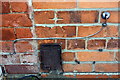
5
Benchmark on #78 Huntingtower Road
Ordnance Survey cut mark benchmark described on the Bench Mark Database at http://www.bench-marks.org.uk/bm57027
Image: © Roger Templeman
Taken: 24 May 2014
0.11 miles
6
#78 Huntingtower Road
There is an OS benchmark Image on the side of the house at the near corner
Image: © Roger Templeman
Taken: 19 Apr 2014
0.11 miles
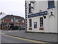
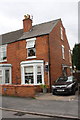
7
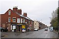
Springfield Road
Terraced houses in Grantham with a corner shop.
Image: © Andrew Tatlow
Taken: 19 Apr 2006
0.12 miles
8
Benchmark on #43 Springfield Road
Ordnance Survey cut mark benchmark described on the Bench Mark Database at www.bench-marks.org.uk/111447
Image: © phil Richards
Taken: 9 Sep 2019
0.13 miles
9
No. 43 Springfield Road
There is an OS benchmark Image on the front of the house at its junction with the house to its left
Image: © phil Richards
Taken: 9 Sep 2019
0.13 miles
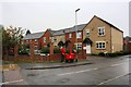
10
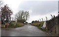
Beside the railway
The main London to Edinburgh is to the right and industrial premises to the left. Lots of chain link fencing and barbed wire.
Image: © Andrew Tatlow
Taken: 19 Apr 2006
0.13 miles