IMAGES TAKEN NEAR TO
Huntingtower Road, GRANTHAM, NG31 7AT
Introduction
This page details the photographs taken nearby to Huntingtower Road, NG31 7AT by members of the Geograph project.
The Geograph project started in 2005 with the aim of publishing, organising and preserving representative images for every square kilometre of Great Britain, Ireland and the Isle of Man.

There are currently over 7.5m images from over14,400 individuals and you can help contribute to the project by visiting https://www.geograph.org.uk
Image Map
Images are licensed for reuse under creativecommons.org/licenses/by-sa/2.0
Notes
- Clicking on the map will re-center to the selected point.
- The higher the marker number, the further away the image location is from the centre of the postcode.
Image Listing (186 Images Found)
Images are licensed for reuse under creativecommons.org/licenses/by-sa/2.0
Image
Details
Distance
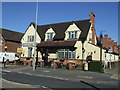
1
Huntingtower Road at the junction of Harlaxton Road
Image: © David Howard
Taken: 6 Aug 2019
0.03 miles
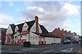
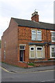
3
Converted pub at Harlaxton Road/Huntingtower Road junction
It was the Huntingtower Arms
Image: © Roger Templeman
Taken: 19 Apr 2014
0.03 miles
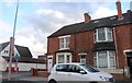
5
#48 Harlaxton Road at junction with Alexandra Road
There is an OS benchmark Image on the side of the house at its junction with the front side wall
Image: © Roger Templeman
Taken: 19 Apr 2014
0.08 miles
6
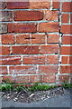
Benchmark on #48 Harlaxton Road
Ordnance Survey cut mark benchmark described on the Bench Mark Database at http://www.bench-marks.org.uk/bm56804
Image: © Roger Templeman
Taken: 19 Apr 2014
0.08 miles
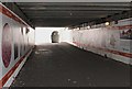
7
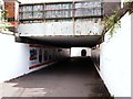
Subway, Grantham Railway Station, Lincs.
The residential area of Huntingtower Road lies behind the photographer. This is a view into the shorter - and perhaps slightly less claustrophobic - of the two subways beneath the station's railway tracks, looking towards the horseshoe-shaped entrance to the subway nearest to the town centre. The more distant tunnel is approximately 100 metres long and 6' 6" inch high and it provides users with access to Station Road. Graphics and art & design students from Grantham College created the series of pictures lining the nearest subway, as part of a joint initiative between Grantham College, London North Eastern Railway (LNER) and South Kesteven District Council. A plot of railway company land on the right of this path, and parallel with it, was where the Grantham Railway Guild once had its extensive club premises. The former Huntingtower Road County Primary School buildings (since replaced by The Huntingtower Community Academy) and former Springfield County Secondary School site - closed in August 1964 - were both located on this side of the tracks.
Image: © David Hallam-Jones
Taken: 3 Aug 2019
0.08 miles
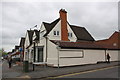
8
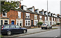
Terraced housing along Harlaxton Road
Harlaxton Road, the A607, heading south out of Grantham.
Image: © Trevor Littlewood
Taken: 10 Nov 2022
0.09 miles
9
Subways beneath Grantham Station, Lincs.
With the residential area of Huntingtower Road behand the photographer, this is a view of the shorter - and perhaps slightly less claustrophobic - subway, looking towards entrance to a second subway. The horse-shoe shaped tunnel ahead is approximately 100 metres long, 6' 6" inch high Station Road and it provides users with access to Station Road. Both of these passages are situated beneath the railway tracks. Graphics and art & design students from Grantham College created the series of pictures seen here as part of a joint initiative between Grantham College, London North Eastern Railway (LNER) and South Kesteven District Council.
Image: © David Hallam-Jones
Taken: 3 Aug 2019
0.10 miles
10
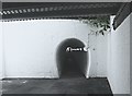
Station Road Subway, Grantham, Lincs.
A pedestrian can be glimpsed ahead in the first of the two subways situated beneath the railway tracks. Ahead lies Station Road, whilst behind the photographer, the second less-claustrophic section of these passageways allows pedestrians access to and from Huntingtower Road. It can probably be safely assumed that these passageways were created at different times, when the tracks where increased in number. The present station was opened in August 1852.
Image: © David Hallam-Jones
Taken: 3 Aug 2019
0.10 miles