Subway, Grantham Railway Station, Lincs.
Introduction
The photograph on this page of Subway, Grantham Railway Station, Lincs. by David Hallam-Jones as part of the Geograph project.
The Geograph project started in 2005 with the aim of publishing, organising and preserving representative images for every square kilometre of Great Britain, Ireland and the Isle of Man.

There are currently over 7.5m images from over 14,400 individuals and you can help contribute to the project by visiting https://www.geograph.org.uk
Subway, Grantham Railway Station, Lincs.
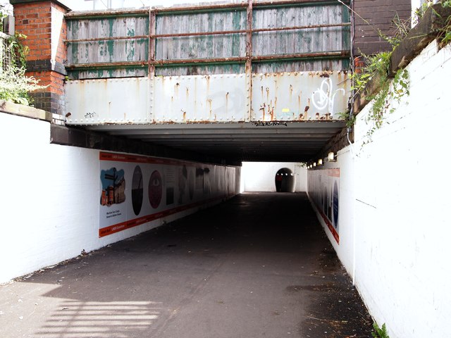
Image: © David Hallam-Jones Taken: 3 Aug 2019
The residential area of Huntingtower Road lies behind the photographer. This is a view into the shorter - and perhaps slightly less claustrophobic - of the two subways beneath the station's railway tracks, looking towards the horseshoe-shaped entrance to the subway nearest to the town centre. The more distant tunnel is approximately 100 metres long and 6' 6" inch high and it provides users with access to Station Road. Graphics and art & design students from Grantham College created the series of pictures lining the nearest subway, as part of a joint initiative between Grantham College, London North Eastern Railway (LNER) and South Kesteven District Council. A plot of railway company land on the right of this path, and parallel with it, was where the Grantham Railway Guild once had its extensive club premises. The former Huntingtower Road County Primary School buildings (since replaced by The Huntingtower Community Academy) and former Springfield County Secondary School site - closed in August 1964 - were both located on this side of the tracks.
Images are licensed for reuse under creativecommons.org/licenses/by-sa/2.0
Image Location
Latitude
52.906866
Longitude
-0.645561