1
Market Cross
A cross is known to have existed in Grantham Market Place since at least 1280. There have been two or three replacements since then and the present one dates from 1884, having been restored in 1910. There was a stream in the market, fed by a spring, and in 1597 it was conduited to a market pump. There was also a water trough and a stone for mounting horses near the Market Cross.
Image: © Peter Langsdale
Taken: Unknown
0.01 miles
2
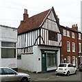
Swinegate, Grantham
The half timbered building is No. 11 and dates from the seventeenth century https://historicengland.org.uk/listing/the-list/list-entry/1062471?section=official-list-entry
Image: © Jonathan Thacker
Taken: 9 Nov 2022
0.02 miles
3
41 Church Trees, Grantham
Dates from the eighteenth century https://historicengland.org.uk/listing/the-list/list-entry/1360232?section=official-list-entry
Image: © Jonathan Thacker
Taken: 9 Nov 2022
0.02 miles
4
Church Trees
Grade II listed early 19th century house on Swinegate
Image: © Richard Croft
Taken: 13 Feb 2014
0.02 miles
5
38A Church Trees, Grantham
Early 19th century house. The original parapetted roof has been replaced at some stage with a later hipped roof with additional attic storey. Some of the windows retain early intersecting glazing bars. Listed Grade II.
Image: © Alan Murray-Rust
Taken: 9 Feb 2017
0.02 miles
6
39 and 40 Church Trees, Grantham
A pair of late 18th century houses in brick, one of two bays, one single. Listed Grade II. No.39 has a fire assurance plaque above the doorway http://www.geograph.org.uk/photo/5281610.
Image: © Alan Murray-Rust
Taken: 9 Feb 2017
0.02 miles
7
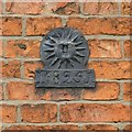
Fire mark, 39 Church Trees
A standard Sun Fire Office plaque, possibly contemporary with the house. See http://www.geograph.org.uk/photo/5281606 for location.
Image: © Alan Murray-Rust
Taken: 9 Feb 2017
0.02 miles
8
Church Trees House, 38a Church Trees
Property is undergoing extensive renovation carried out to change it from flats back to its original Victorian/Georgian style
Image: © Peter
Taken: 11 Jan 2021
0.02 miles
9
Artichoke House, 11 Swinegate, Grantham
Timber framed house, probably 17th century. The name comes from the old public house which was situated to the left, now demolished. Listed Grade II.
Image: © Alan Murray-Rust
Taken: 9 Feb 2017
0.02 miles
10
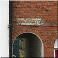
Marshall's Yard, Swinegate, Grantham
Now simply access to the back premises of 12 Swinegate, yards like this would have contained a range of small dwellings. In this instance, early maps show 4 or 5.
Image: © Alan Murray-Rust
Taken: 9 Feb 2017
0.02 miles


