IMAGES TAKEN NEAR TO
East Street, GRANTHAM, NG31 6QW
Introduction
This page details the photographs taken nearby to East Street, NG31 6QW by members of the Geograph project.
The Geograph project started in 2005 with the aim of publishing, organising and preserving representative images for every square kilometre of Great Britain, Ireland and the Isle of Man.

There are currently over 7.5m images from over14,400 individuals and you can help contribute to the project by visiting https://www.geograph.org.uk
Image Map
Images are licensed for reuse under creativecommons.org/licenses/by-sa/2.0
Notes
- Clicking on the map will re-center to the selected point.
- The higher the marker number, the further away the image location is from the centre of the postcode.
Image Listing (675 Images Found)
Images are licensed for reuse under creativecommons.org/licenses/by-sa/2.0
Image
Details
Distance
1
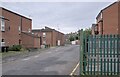
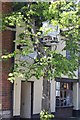
Agnes Street
Agnes Street in Grantham. An area that was once a maltings which was cleared in the late 1970s and replaced with sheltered accommodation for the elderly, and called the Riverside Complex.
Image: © Bob Harvey
Taken: 4 Aug 2024
0.05 miles
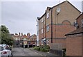
2
Junction of Welham Street and East Street
Image: © Roger Templeman
Taken: 19 Apr 2014
0.05 miles
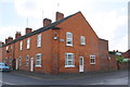
3
Agnes Street
The three storey building is an apartment house, for 6 homes. Beyond is the former Victorian school, now a childcare facility called "Stepping Stones".
The school building is Locally Listed - see https://heritage-explorer.lincolnshire.gov.uk/Monument/MLI126760 .
Image: © Bob Harvey
Taken: 4 Aug 2024
0.05 miles
4
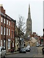
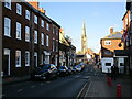
Castlegate, Grantham
A street full of historic buildings with the spire of St Wulfram's Church as backdrop.
Image: © Alan Murray-Rust
Taken: 9 Feb 2017
0.05 miles
5
The Beehive Inn 10-11 Castlegate
Image: © Jo and Steve Turner
Taken: 2 May 2011
0.05 miles
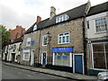
7
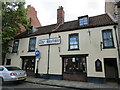
The Beehive, Grantham
Dates from the laet eighteenth century https://historicengland.org.uk/listing/the-list/list-entry/1360266?section=official-list-entry
Image: © Jonathan Thacker
Taken: 14 Jul 2019
0.05 miles
8
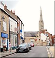
Finkin Street Vicinity, Grantham, Lincs.
Stationary cars on Castlegate near its junction with Finkin Street. St Wulrum's Church, in the distance, can be reached by continuing along on Castlegate on foot, this being a one-way street.
Image: © David Hallam-Jones
Taken: 4 Aug 2019
0.05 miles
9
Castlegate, Grantham
The stone built houses date from the eighteenth century https://historicengland.org.uk/listing/the-list/list-entry/1062514?section=official-list-entry
Image: © Jonathan Thacker
Taken: 14 Jul 2019
0.05 miles
10
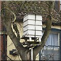
Inn sign with a difference
See http://www.geograph.org.uk/photo/5280766 for location.
Image: © Alan Murray-Rust
Taken: 9 Feb 2017
0.06 miles