IMAGES TAKEN NEAR TO
Brook Street, GRANTHAM, NG31 6PS
Introduction
This page details the photographs taken nearby to Brook Street, NG31 6PS by members of the Geograph project.
The Geograph project started in 2005 with the aim of publishing, organising and preserving representative images for every square kilometre of Great Britain, Ireland and the Isle of Man.

There are currently over 7.5m images from over14,400 individuals and you can help contribute to the project by visiting https://www.geograph.org.uk
Image Map
Images are licensed for reuse under creativecommons.org/licenses/by-sa/2.0
Notes
- Clicking on the map will re-center to the selected point.
- The higher the marker number, the further away the image location is from the centre of the postcode.
Image Listing (593 Images Found)
Images are licensed for reuse under creativecommons.org/licenses/by-sa/2.0
Image
Details
Distance
1
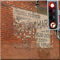
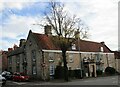
Old painted advertisement, Swinegate, Grantham
Advertising 'Best British leather and repairing sundries, wholesale and retail suppliers'. This typifies the overlap between production and selling of the period compared with today's more specialised businesses.
Image: © Alan Murray-Rust
Taken: 9 Feb 2017
0.00 miles
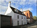
2
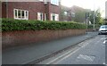
21 Swinegate, Grantham
Early 18th century house of 3 bays, rendered. The windows show evidence that the road surface has been raised over the years. Listed Grade II.
Image: © Alan Murray-Rust
Taken: 9 Feb 2017
0.01 miles
3
21 Swinegate, Grantham
Dates from the early eighteenth century https://historicengland.org.uk/listing/the-list/list-entry/1360247?section=official-list-entry
Image: © Jonathan Thacker
Taken: 9 Nov 2022
0.01 miles
4
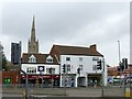
44 and 46 Watergate, Grantham
These are the right hand pair; built as a single unit, with central carriage arch. Early 19th century, Listed Grade II.
Image: © Alan Murray-Rust
Taken: 9 Feb 2017
0.03 miles
6
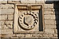
Farish Almshouses date stone
Date stone on number 10 Brownlow Street http://www.geograph.org.uk/photo/327414
Image: © Richard Croft
Taken: 2 Feb 2007
0.03 miles
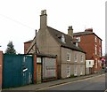
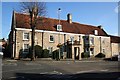
7
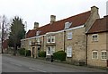
2 Brownlow Street, Grantham
17th century stone house, built 1653 http://www.geograph.org.uk/photo/5281631 by Thomas Hurst, who founded the almshouses on Church Trees http://www.geograph.org.uk/photo/5280725 . Listed Grade II.
Image: © Alan Murray-Rust
Taken: 9 Feb 2017
0.04 miles
8
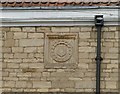
Datestone, 2 Brownlow Street, Grantham
See http://www.geograph.org.uk/photo/5281626 for location.
Image: © Alan Murray-Rust
Taken: 9 Feb 2017
0.04 miles
9
10 Brownlow Street, Grantham
Dates from 1643 https://historicengland.org.uk/listing/the-list/list-entry/1360262?section=official-list-entry
Image: © Jonathan Thacker
Taken: 9 Nov 2022
0.04 miles
10
Miss Farish Almshouses
Number 10 Brownlow Street, known as Miss Farish Almshouses, has a datestone of 1653
Image: © Richard Croft
Taken: 2 Feb 2007
0.04 miles