IMAGES TAKEN NEAR TO
Station Road, GRANTHAM, NG31 6JY
Introduction
This page details the photographs taken nearby to Station Road, NG31 6JY by members of the Geograph project.
The Geograph project started in 2005 with the aim of publishing, organising and preserving representative images for every square kilometre of Great Britain, Ireland and the Isle of Man.

There are currently over 7.5m images from over14,400 individuals and you can help contribute to the project by visiting https://www.geograph.org.uk
Image Map
Images are licensed for reuse under creativecommons.org/licenses/by-sa/2.0
Notes
- Clicking on the map will re-center to the selected point.
- The higher the marker number, the further away the image location is from the centre of the postcode.
Image Listing (342 Images Found)
Images are licensed for reuse under creativecommons.org/licenses/by-sa/2.0
Image
Details
Distance
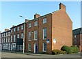
1
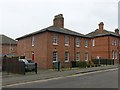
6-7 Station Road, Grantham
Pair of cottages built c.1850 by the Great Northern Railway for its employees. Listed Grade II. The group of houses at the foot of Station Road show clearly the gradation of size of dwelling depending on the status of the employees provided for. http://www.geograph.org.uk/photo/5282548 http://www.geograph.org.uk/photo/5282554
Image: © Alan Murray-Rust
Taken: 9 Feb 2017
0.01 miles
2
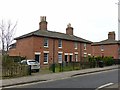
2?5 Station Road, Grantham
Group of 4 cottages built c.1850 by the Great Northern Railway for its employees. Listed Grade II. The group of houses at the foot of Station Road built by the railway company show clearly the gradation of size of dwelling depending on the status of the employees provided for. See also http://www.geograph.org.uk/photo/5282550 http://www.geograph.org.uk/photo/5282554
Image: © Alan Murray-Rust
Taken: 9 Feb 2017
0.01 miles
3
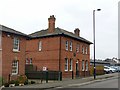
8 Station Road, Grantham
House built c.1850 by the Great Northern Railway possibly for the Station Master. Listed Grade II. The group of houses at the foot of Station Road built by the railway company show clearly the gradation of size of dwelling depending on the status of the employees provided for. http://www.geograph.org.uk/photo/5282548 http://www.geograph.org.uk/photo/5282550
Image: © Alan Murray-Rust
Taken: 9 Feb 2017
0.01 miles
5
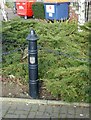
Bollard outside The Maltings, Wharf Road, Grantham
The shield on the post is that of the City of Nottingham; it is puzzling how it comes to be erected here.
Image: © Alan Murray-Rust
Taken: 15 Feb 2017
0.04 miles
6
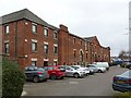
The Maltings, Wharf Road, Grantham
Mid 19th century, now converted to business use. Listed Grade II. Some of the detail recorded in the Listing has been lost in the course of conversion, such as iron bars protecting the windows.
Image: © Alan Murray-Rust
Taken: 9 Feb 2017
0.04 miles
7
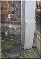
Benchmark on railway bridge over Harlaxton Road
Ordnance Survey cut mark benchmark described on the Bench Mark Database at http://www.bench-marks.org.uk/bm57552
Image: © Roger Templeman
Taken: 19 Apr 2014
0.05 miles
8
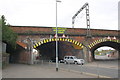
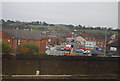
Railway bridge over Harlaxton Road
There is an OS benchmark Image on the bridge pier between the pavement on the right hand side of the image and the road, left of the grey down pipe
Image: © Roger Templeman
Taken: 19 Apr 2014
0.05 miles
9
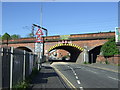
Railway bridge over Harlaxton Road, Grantham
Image: © JThomas
Taken: 26 May 2012
0.05 miles
10
Newton House, 40 Westgate, Grantham
Early 19th century house, now offices; earlier maps show it as two dwellings, and it probably originally had a side entrance. Listed Grade II as a unit with the pair of houses beyond.
There is a bench mark http://www.geograph.org.uk/photo/5282534 on the corner, facing the street.
Image: © Alan Murray-Rust
Taken: 15 Feb 2017
0.06 miles