IMAGES TAKEN NEAR TO
Welby Street, GRANTHAM, NG31 6EA
Introduction
This page details the photographs taken nearby to Welby Street, NG31 6EA by members of the Geograph project.
The Geograph project started in 2005 with the aim of publishing, organising and preserving representative images for every square kilometre of Great Britain, Ireland and the Isle of Man.

There are currently over 7.5m images from over14,400 individuals and you can help contribute to the project by visiting https://www.geograph.org.uk
Image Map
Images are licensed for reuse under creativecommons.org/licenses/by-sa/2.0
Notes
- Clicking on the map will re-center to the selected point.
- The higher the marker number, the further away the image location is from the centre of the postcode.
Image Listing (425 Images Found)
Images are licensed for reuse under creativecommons.org/licenses/by-sa/2.0
Image
Details
Distance
1
25-26 Westgate, Grantham
A pair of early 19th century houses, each of just one bay, so really quite small, with later shop fronts. Listed Grade II.
Image: © Alan Murray-Rust
Taken: 9 Feb 2017
0.03 miles
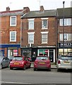
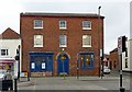
2
24 Westgate, Grantham
Early 19th century, probably built as retail premises as there are warehouse-type loading doors to the upper floors on the Welby Street frontage. Listed Grade II.
Image: © Alan Murray-Rust
Taken: 9 Feb 2017
0.03 miles
3
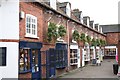
Blue Court
Small shopping area off Guildhall Street
Image: © Richard Croft
Taken: 16 Nov 2006
0.03 miles
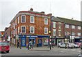
4
23 Westgate, Grantham
Now the New Era restaurant, formerly the Blue Man public house. 18th century, possibly built as an inn, Listed Grade II.
Image: © Alan Murray-Rust
Taken: 9 Feb 2017
0.03 miles
6
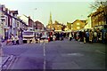
Open air market on Westgate, Grantham, 1979
The Blue Bull Public House is extreme left.
Image: © Nigel Thompson
Taken: 24 Nov 1979
0.04 miles
7
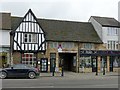
21 Westgate, Grantham
Specifically just the left hand portion of the range with the timber framed gable. This is of early 17th century date and Listed Grade II, the remainder of the building to the right being modern and not included in the Listing. The whole was formerly the Malt Shovel Inn.
Image: © Alan Murray-Rust
Taken: 9 Feb 2017
0.04 miles
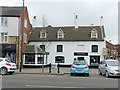
9
31 Westgate, Grantham
Looking like an ample single house, this is in fact two, the right hand part belonging to 21 Stanton Street. Clearly the speculative developers of the time were no less skilled at creating features that may have allowed them to mark up the price of their wares than those of the present day. Early 19th century, Listed Grade II.
Image: © Alan Murray-Rust
Taken: 9 Feb 2017
0.04 miles
10
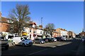
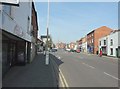
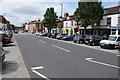
Westgate, Grantham
Part of the Grantham Conservation Area http://www.southkesteven.gov.uk/CHttpHandler.ashx?id=3092&p=0, which includes the medieval part of the town developed around St Wulfram's church (spire, far right).
Image: © Tim Heaton
Taken: 9 Mar 2021
0.05 miles